Any views expressed within media held on this service are those of the contributors, should not be taken as approved or endorsed by the University, and do not necessarily reflect the views of the University in respect of any particular issue.
Digimap is an online map and data delivery service, available by subscription to UK Higher and Further Education establishments. Operated by EDINA at the University of Edinburgh, Digimap offers a number of data collections, including Ordnance Survey, historical, geological, aerial photography, LiDAR, marine maps, land cover mapping, global mapping and census data. For more information about Digimap go to our website: https://digimap.edina.ac.uk Background image Contains OS data (c) Crown Copyright and database right 2022
MapAction is a a volunteer-based charity and non-governmental organisation which works in disaster zones providing frequently updated situation maps showing where relief help is most urgently needed.
The earthquake in Haiti has killed all but two members of the Haitian national mapping agency (the equivalent of Ordnance Survey). At Digimap’s 10th Anniversary event on 20th January 2010, Vanessa Lawrence, Ordnance Survey’s Chief Executive and Director General, took a moment to tell of the work that MapAction are doing in Haiti and encouraged donations to this cause.
Donations can be made online directly from the MapAction website: http://mapaction.org/.
The following may be of interest to those Digimap users who have ArcGIS 9.3.1 and are using raster catalogs.
ESRI have just released a patch fixing the issue with Microsoft SQL Server and Raster Catalogues. This works with ArcGIS 9.3.1 Service Pack 1.
ESRI’s announcement is as follows:
“ESRI announces ArcSDE 9.3.1 SP1 SQL Server Raster Catalog and Raster Field Patch. This patch addresses the raster catalog display and raster field identify problem for SQL Server following the install of 9.3.1 sp1. We recommend that all who store raster catalogs or raster fields in ArcSDE for SQL Server download and install this Patch at their earliest convenience to ensure the highest quality experience when working with ArcSDE 9.3.1 Service Pack 1.”
We have recently noticed that some Hotmail accounts are rejecting emails from edina@ed.ac.uk as spam. This also includes emails which have been automatically forwarded to a Hotmail account from an institutional email account (.ac.uk).
This means that some users may not receive emails from which to download OS MasterMap data or their “Welcome to Digimap” registration confirmation.
If you believe you are not receiving emails from EDINA, please check that you have edina@ed.ac.uk in your Hotmail list of Safe Senders.
On 26 January, the Digimap Classic mapping facility available in the OS Collection will be removed and will no longer be available for use. NOTE: ALL OTHER DIGIMAP FACILITIES WILL REMAIN AS THEY ARE.
Any maps present in your Classic Map Chest on 26 January will be lost. Please ensure that you print or save any maps that you require before 26 January. Please contact the EDINA Helpdesk (edina@ed.ac.uk) if you require any assistance in saving or printing maps from Classic.
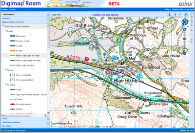
The new Roam facility (released in October 2009) replaces Classic as the standard mapping facility in Digimap OS Collection. Key features of Roam include: 12 fixed scale map views, click-and-drag navigation or “slippy maps” and enhanced printing options enabling you to generate printable PDF maps in landscape or portrait and A4 or A3 size. Roam is a significant improvement on Classic, providing many enhanced futures and an easier to use, more intuitive user interface.
EDINA is holding a celebratory event to mark the 10th anniversary of the launch of the Digimap service on the 20th January 2010. All Digimap site reps and support staff are invited to join us in Edinburgh to mark the occasion.
During the day, there will be a number of speakers and demonstrations to showcase the Digimap service past, present and future and in the evening there will be a drinks reception followed by dinner with guest speaker, Mike Parker (television presenter and author of ‘Map Addict’).
The daytime event will be free of charge with lunch and refreshments provided. Tickets for the evening event (including drinks reception) will be available for £24 (or £30 including wine).
Site reps and Support staff can find out more details and register for the event here:
Productivity Suite 2.0 – Unlocking the Full Potential of Ordnance Survey Data
It is being held on Wednesday 4 November 2009, 10:00 – 11:00 am
If you are using Ordnance Survey data from Digimap and your institution has a licence to use ArcGIS, you might find this a useful event to attend. Licensing ArcGIS via Chest includes the Productivity Suite, an additional software application providing data conversion tools. Productivity Suite does not cost extra, but should be requested specifically when the Chest licence is purchased.
Note: you will need the Generic Colour Postscript PPD file linked in the document if you want to print A3 or larger. You can download the PDD file from the above website.
Load the PDF into Acrobat and then go to File ->Print. Select CutePDF Writer (or another Postscript printer you have installed). Click on Properties and then the Advanced… button.
There is a section called Postscript Options; expand this to find the PostScript Output Option and change this from ‘Optimize for Speed’ to ‘Encapsulated Postscript (EPS)’.
When you print you will now be asked to save a file which you should add the extension .eps to your file. You should be able to open this file in Ghostview as a vector EPS.
Since Digimap ceased to generate EPS files we have had a number of enquiries about suitable alternatives. Currently, Digimap’s mapping facilities will only produce PDF files. However, there are a number of options for those who prefer to use other formats. The following notes may help.
Note that EDINA does not endorse or recommend any of the products or services detailed here or guarantee their quality or performance.
PDF files generated from Digimap can be converted to various other formats including PNG, SVG, and PS/EPS using free software called Inkscape (http://www.inkscape.org/). The only down side to this that we have found is that it seems to blur the PS/EPS because of the ‘Digimap’ watermark.
You can also edit the vectors in Inkscape. If you want to put the map (or a bit of it) into a Word document there is a nifty little command in Acrobat under Tools –> Select & Zoom–> Snapshot Tool which allows you to define an area and then paste it into Word (or another programme) – note this is lower resolution than you can create with Inkscape.
The PDFs themselves can be opened in CS3 Adobe Illustrator as editable vector graphics and then exported to various formats. The PDFs can also be opened and converted to EPS in GhostView but this seems to treat them as images rather than vectors.
There are various software packages that will convert from vector PDF to DXF (e.g. http://www.trixsystems.com/pdfFLY.html) but we have not found any which are free of charge.
If DXF/DWG is required for OS MasterMap, the best option is to download GML and use Dotted Eyes’ InterpOSe software to convert from GML to DXF/DWG.
Today, Monday 5 October, a new mapping tool is available to all registered users, through Digimap’s Ordnance Survey Collection.
Roam, the new mapping facility, is available as a BETA service and will therefore be subject to various improvements over the next few months. Planned changes include:
– additional print formats as alternatives to PDF
– inclusion of scalebar on printed maps
– provision of scale and extent indication on screen maps
– adding a “My Maps” function for bookmarking maps
Roam offers “click and drag” functions to locate your map, 12 map views at different scales, printing in PDF at both A3 and A4 sizes, search by place name, postcode or grid reference, seamless scrolling through the fixed scale maps and 5 customisable map views. You can access Roam from the icon above Classic in Digimap’s Ordnance Survey Collection home page.
We hope you will use the new facility and let us know what you think of it. There is a link within Roam for you to report any feedback you have (positive and negative). You can also email us on edina@ed.ac.uk or telephone us on 0131 650 3302.
Roam will replace the current Classic facility in January 2010.