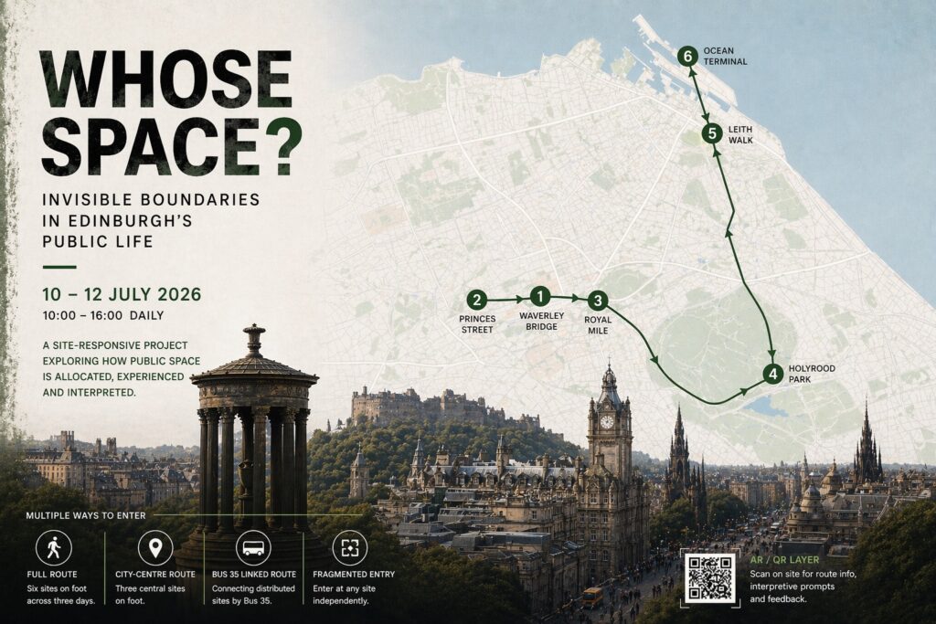
image_pdfimage_print

Speculative Individual Curatorial Project

Whose Space?

Invisible Boundaries in Edinburgh’s Public Life

Project Overview

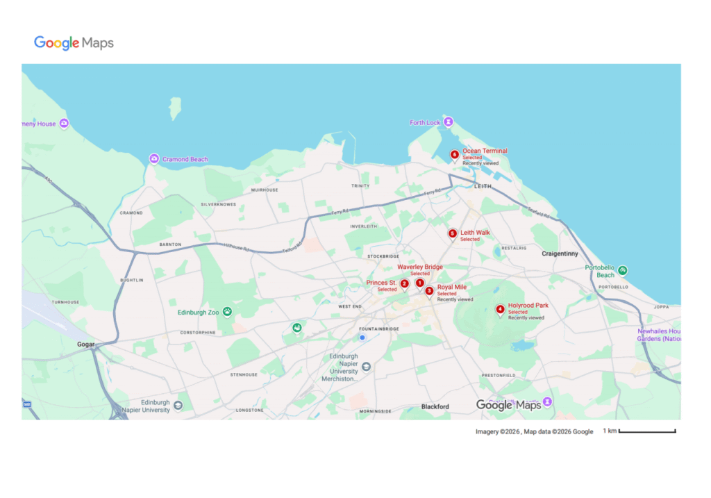
Sites: Waverley Bridge, Princes Street, Royal Mile, Holyrood Park, Leith Walk, and Ocean Terminal, Edinburgh

Project Dates: 10 July 2026 – 12 July 2026

Opening Hours: 10:00am–4:00pm daily

Duration: 3 days

Curator: Hazel Ren

Lead Image

Figure 1. Main visual for the curatorial project Whose Space? Invisible Boundaries in Edinburgh’s Public Life, showing an overlooking view of Edinburgh and the six project sites. Graphic by Author, 2026.

Curatorial Text

Whose Space? Invisible Boundaries in Edinburgh’s Public Life is a three-day public curatorial project distributed across six sites in Edinburgh: Waverley Bridge, Princes Street, Royal Mile, Holyrood Park, Leith Walk, and Ocean Terminal. The project begins with a direct question: in a city that appears open to everyone, who is actually able to stay, who can only pass through, whose presence is naturally accepted, and who remains at the margins?

Figure 2. Site distribution across Edinburgh showing the six project locations. Graphic by Author, based on Google Maps.

This project examines public space as a structure that organises speed, duration of stay, visibility, and modes of movement. It therefore does not treat public space as a setting, but as a mechanism that actively structures experience. Commercial streets, transport nodes, heritage tourist areas, parks, and redevelopment zones all fall within the scope of “public life”, yet they offer different modes of entry to different groups. These differences are rarely stated directly. More often, they are embedded within everyday routes, consumer logic, and patterns of spatial use.

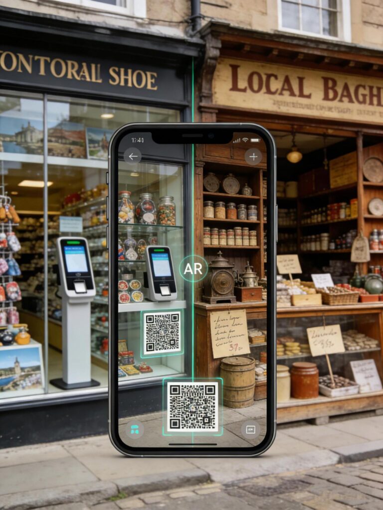
Through three site-responsive artistic interventions, one slow-walk performance, two public classification and feedback devices, and a light AR and QR-code interpretive layer, the project turns everyday movement into a way of reading the city. It does not treat “residents” and “tourists” as fixed categories. Instead, it focuses on how these positions are continually produced through route, rhythm, density, the tourist economy, public transport, and habitual uses of space. AR remains in a supporting role here, only enabling layered reading and route recognition at selected sites.

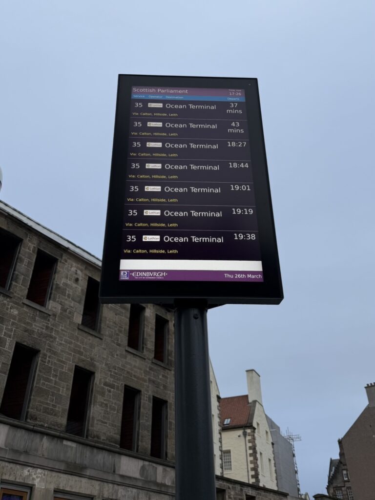
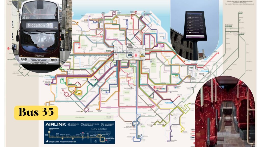
The project adopts a multi-route structure. Viewers may choose the full route, the city-centre route, the Bus 35-linked route, or begin from any single site. In the high-density central areas, movement is on foot, while the more dispersed sites are served by Bus 35 during off-peak hours. Public transport, therefore, becomes a direct expression of changing urban rhythms.

What this project is concerned with is not the number of attractions, but how different spaces are allocated, used, and experienced. It invites viewers to reread Edinburgh. The city is not made up only of a small number of repeatedly viewed landmarks, but of a public network shaped by different speeds, densities, and conditions of entry.

Artists / Participants
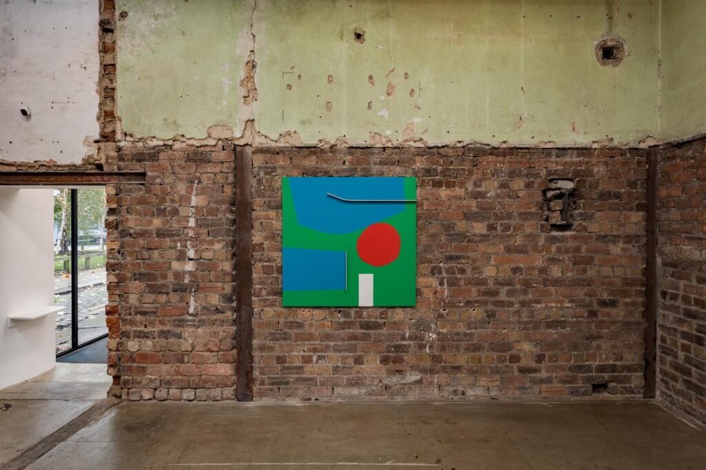
Toby Paterson

Toby Paterson is an artist born in Glasgow and long based there, and a graduate of the Glasgow School of Art. His practice has consistently focused on architectural surfaces, urban visual language, and the ways in which modernist space is viewed and remembered. His work often reconfigures perceptions of urban facades and public structures through painting, relief, and installation. In this project, Paterson responds to Princes Street. The collaboration takes the form of site-responsive co-development, focusing on removable floor graphics, directional prompts, and pause markers. The key issue at Princes Street lies in its commercial frontage, high visibility, and heavy pedestrian flow, and so it requires a visual method capable of dealing directly with urban surfaces and pedestrian order. Paterson’s participation will help the project present more clearly the logic of consumption and the structure of viewing within public space in the city centre.
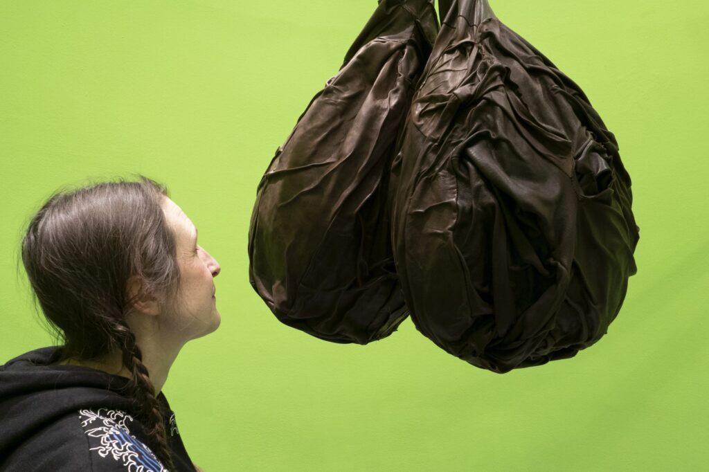
Figure 3. Toby Paterson, installation view, The Modern Institute, Aird’s Lane Bricks Space, 15 November 2024–15 January 2025. Image source: The Modern Institute.

Clara Ursitti

Clara Ursitti is a Canadian-born artist who has long lived and worked in Glasgow. Since the 1990s, she has worked with smell, installation, and intervention-based practice, focusing on the influence of scent on social, psychological, and spatial experience. Her work pays close attention to non-visual perception and often organises bodily experience through a specific site. In this project, Ursitti’s response to Holyrood Park takes the form of low-intensity, site-responsive development, using scent, short textual prompts, and light interventions. Holyrood Park is given the function of rhythmic transition within the project, allowing viewers to move out of the high-pressure flows of the city centre into a slower and more open spatial condition. The value of Ursitti’s method here lies not only in the use of scent as a medium but in the fact that her practice is itself rooted in situation and context, and can therefore genuinely reinforce perceptual slowing-down, allowing bodily experience to become part of the reading of urban structure.
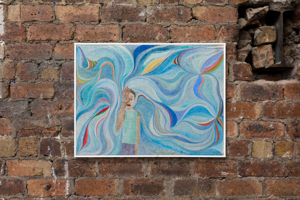
Clara Ursitti Amik, 2022
Figure 4. Clara Ursitti, olfactory installation view. Image source: artist / institutional documentation.

Chris Johanson

Chris Johanson is an artist born in San Jose and now living and working in Los Angeles and Portland. He is often associated with street culture, DIY ethos, painting, text, sculpture, and installation. His work has long engaged with social relations, the environment, and value judgements within everyday life. In this project, Johanson responds to Leith Walk. The collaboration takes the form of text-based, light public intervention developed through co-creation, focusing on the organisation of language, image, and graphic elements. Leith Walk represents a form of urban space shaped by everyday circulation and ongoing movement. What is needed here is not a strong spectacle, but a mode of intervention that makes “passing through”, “staying, “watching, and “ignoring” more legible. Johanson’s participation will help the project establish a clearer reading structure within the rhythms of everyday urban life.

Figure 5. Chris Johanson, Impermanence #9 (Ron from the past says hello to me in the present), 2025. Acrylic and house paint on recycled canvas, 57.2 × 76.5 × 2 cm. Image source: artist documentation.

Slow-walk Performer

The slow-walk performance on the Royal Mile will be carried out by one external performer. This role is the project’s only repeated bodily intervention, taking place three times a day as a low-intensity, non-amplified, non-gathering slow-walk performance. The performer will move at a very slow pace along a short, defined route, without blocking the main thoroughfare or generating a large crowd. The collaboration takes the form of performance execution, with emphasis on speed control, route discipline, and site rhythm rather than characterisation. The Royal Mile is the most tourist-dense and strongly directed site within the whole project, making it the most suitable place to turn “slowness”, “waiting”, and an “out-of-time rhythm” into immediate lived experience through bodily speed difference. This role pushes the project’s thinking about speed, duration of stay, and conditions of viewing from text and route structure into a directly perceivable action.

Spaces and Locations

This project unfolds across six different sites in Edinburgh, each corresponding to a different kind of public-space boundary: entry boundary, commercial visibility boundary, heritage tourism boundary, urban/nature boundary, everyday circulation boundary, and redevelopment boundary. Each site performs a different function, and together they form the spatial structure of the project.

Figure 6. Central high-density sites: Royal Mile, Waverley Bridge, and Princes Street. Photographs compiled by the author, 2026.

1. Waverley Bridge

Boundary type: Entry and Transportation Boundary
Spatial role: Project entry / first public data point

Waverley Bridge is the starting point of the project and functions as both an entry threshold and a transport threshold. Located at the intersection of the city centre, tourist flows, and public transport, it is the most suitable site for addressing the question of how people enter the project.

Elements: project information board, six-site map, QR-code entry point, identity classification button device.
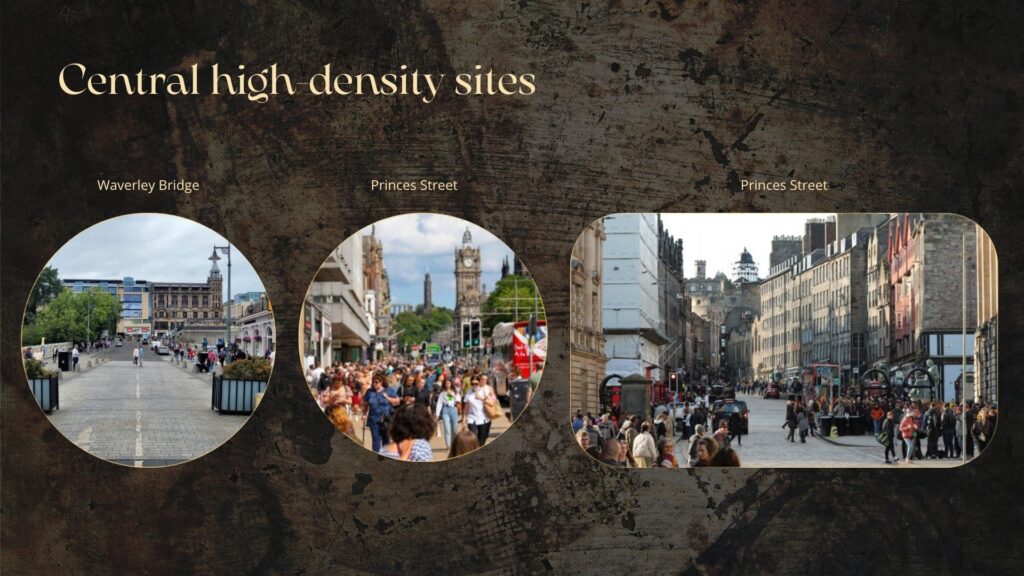
2. Princes Street

Boundary type: Commercial Visibility Boundary
Spatial role: High-density commercial site

Princes Street represents a form of central public space organised through commercial frontage, display logic, and heavy pedestrian flow. It is where the relationship between consumption, passing through, and visibility is most concentrated.

Elements: removable floor graphics, boundary lines, pause prompts, and directional markers.
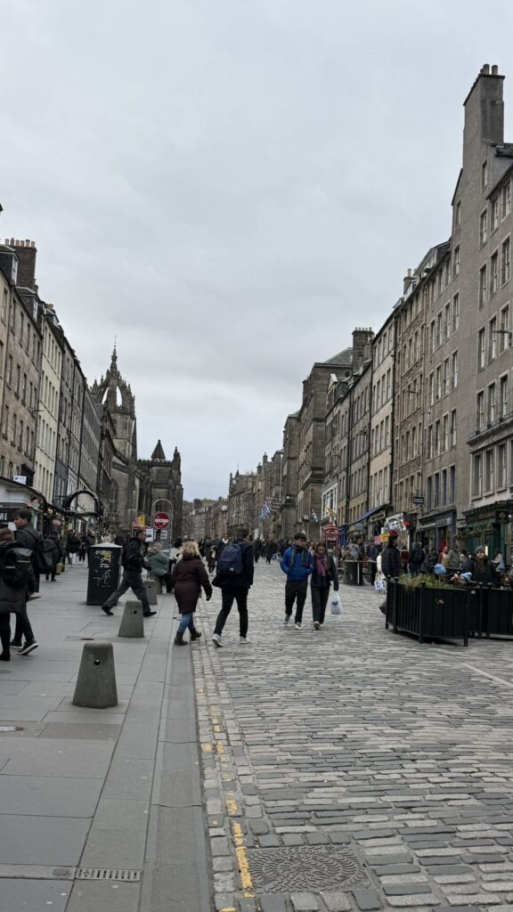
3. Royal Mile

Boundary type: Heritage Tourism Boundary
Spatial role: High-density heritage tourism site/performance intervention site

Royal Mile addresses the historical landscape that is continuously consumed within the tourist city. Through the slow-walk performance, it creates a bodily difference in speed, allowing “slowness, “waiting, and an “out-of-time rhythm” to be experienced directly.

Elements: three daily low-intensity, non-amplified, non-gathering slow-walk performances.
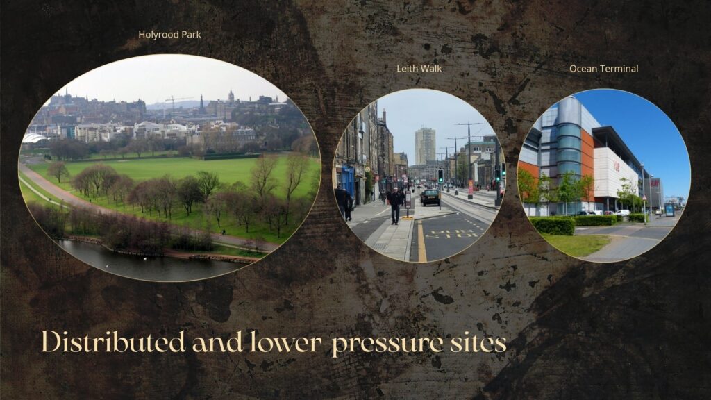
Figure 7. Distributed and lower-pressure sites: Leith Walk, Holyrood Park, and Ocean Terminal. Photographs compiled by the author, 2026.

4. Holyrood Park

Boundary type: Urban / Nature Boundary
Spatial role: Rhythmic transition point

Holyrood Park allows viewers to move from the high-pressure flows of the city centre into a slower and more open spatial condition. Within the project, it functions as a point of rhythmic slowing down and perceptual transition.

Elements: low-intensity sensory intervention, short textual prompts, AR-supported interpretation.
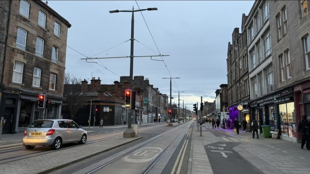
5. Leith Walk

Boundary type: Everyday Circulation Boundary
Spatial role: Comparative site of everyday urban circulation

Leith Walk represents a form of urban space shaped not by tourist spectacle, but by everyday movement and circulation. In contrast to the city centre, it highlights the relationship between circulation, duration of stay, and being overlooked.

Elements: text-based public intervention / light graphic installation.

6. Ocean Terminal

Boundary type: Redevelopment Boundary
Spatial role: Project endpoint / second public data point/feedback site

Ocean Terminal is the final site of the project and the point at which viewers are invited to reassess the whole route. It also represents the spatial logic of redevelopment, waterfront retail, and lower-density movement outside the city centre.

Elements: button feedback device, QR-code questionnaire, project end-point information board.

Route Options

The project adopts a non-linear route structure. Viewers may choose different modes of entry according to time, stamina, and interest. The three route options and the fragmented-entry model all begin from the same core principle: to re-experience Edinburgh’s public space as something allocated, used, and viewed through the connection of different types of boundaries.
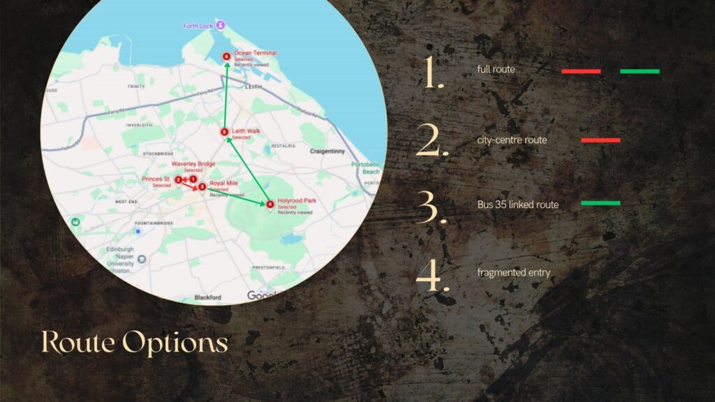
Figure 8. Route structure showing the full route, city-centre route, Bus 35 linked route, and fragmented entry. Graphic by Author, based on Google Maps.

1. Full Route

Route: Waverley Bridge → Princes Street → Royal Mile → Holyrood Park → Leith Walk → Ocean Terminal
Mode of movement: walking + Bus 35
Suggested duration: approximately 4.5–5.5 hours

The full route presents the project’s most complete comparative structure. Viewers begin from the city-centre entry and transport threshold, move through the commercial visibility boundary and the heritage tourism boundary, then reach the urban/nature boundary and the everyday circulation boundary, before finally arriving at the redevelopment boundary and the project end-point feedback site. In this way, they experience in sequence how different spaces organise speed, duration of stay, and modes of entry.

2. City-Centre Route

Route: Waverley Bridge → Princes Street → Royal Mile
Mode of movement: walking
Suggested duration: approximately 60–90 minutes

This route concentrates on the project’s strongest high-density spatial conditions. Within a shorter timeframe, viewers experience the relationship between entry boundary, commercial visibility boundary, and heritage tourism boundary, and observe how public space in the city centre is consumed, organised, and accelerated.

3. Bus 35 Linked Route

Route: Royal Mile → Holyrood Park → Leith Walk → Ocean Terminal
Mode of movement: walking + Bus 35
Suggested duration: approximately 90–120 minutes

This route begins from a high-density heritage tourism site and uses Bus 35 during off-peak hours to connect the more dispersed sites, moving in turn through the urban/nature boundary, the everyday circulation boundary, and the redevelopment boundary. Public transport here is not only a means of connection, but also part of how viewers perceive changing urban rhythm.

Figure 9. Bus 35 as part of the project’s route infrastructure. Images compiled by the author from route-testing materials and transport references.

4. Fragmented Entry

Mode of entry: entry from any single site
Mode of movement: self-directed combination through map, QR-code system, and on-site guidance
Suggested duration: 30 minutes–2 hours

The project does not assume that all viewers enter public space in the same order, at the same pace, or with the same degree of attention. It therefore treats difference in entry conditions as an inseparable part of public-space experience itself. Viewers may begin from any site, and determine the duration of their stay and their onward route according to their own time, mobility, and interests. In this way, the project responds to the uneven ways in which urban space is actually used, crossed, and perceived.

Public Programme

All parts of the public programme are designed as self-guided participation. Viewers may therefore choose their own point of entry, route sequence, and duration of stay during the daily opening hours of 10:00–16:00, using the project map, QR-code system, light AR interpretive layer, and on-site guidance. On-site staff is responsible only for supervising artworks and public devices, maintaining basic order, and carrying out safety observation where necessary. They do not provide guided interpretation.

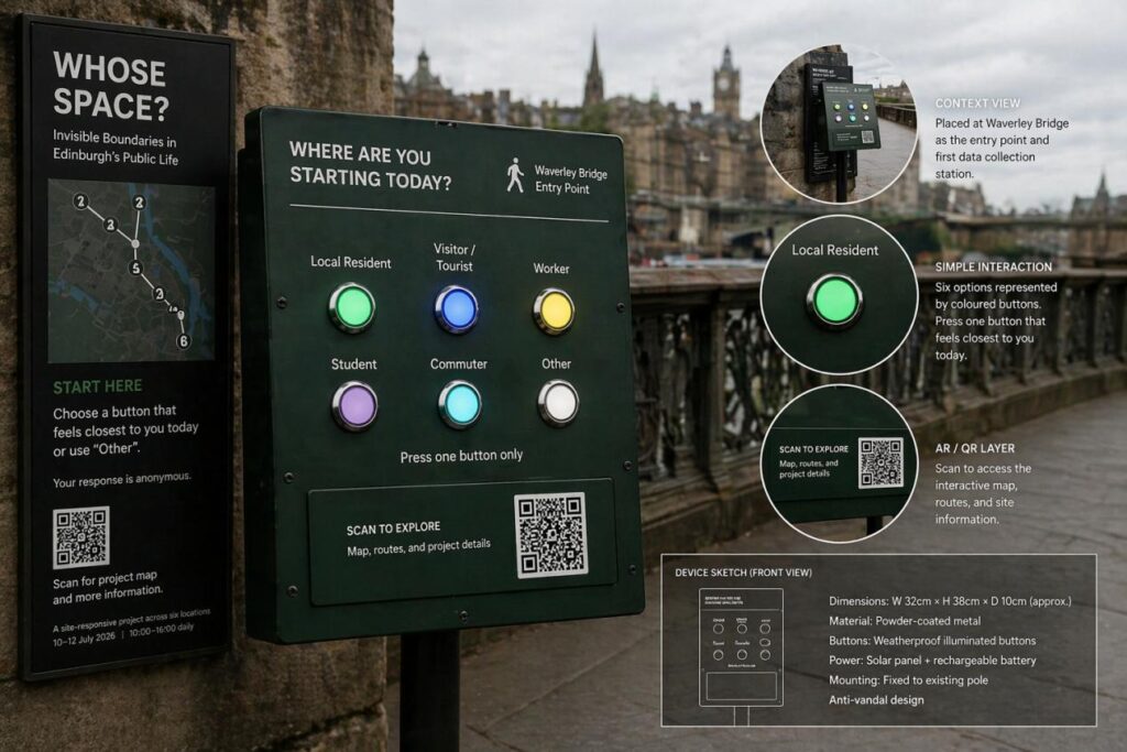
1. Waverley Bridge Entry and Public Classification Device

Time: daily, 10:00–16:00
Format: project information board, six-site map, QR-code entry point, identity classification buttons

Waverley Bridge is the entry point of the project. It provides access to the project introduction, route map, and guide page. Viewers may also use the button device to select an identity category that feels closest to their own, or define one themselves. This device functions both as an entry explanation and as a first layer of public data collection.

2. Royal Mile Slow-walk Performance

Time: daily at 11:30, 13:30, and 15:30
Duration: 30 minutes per performance
Performer: 1 external performer
Format: low-intensity, non-amplified, non-gathering slow-walk intervention

The slow-walk performance at Royal Mile is the project’s only repeated bodily intervention. The performer will move very slowly along a short, defined route without blocking the main passage or generating a large crowd. The three daily performances make it possible for viewers entering the project at different times to encounter this intervention. Through a minimal difference in speed, it turns “slowness”, “waiting”, and an “out-of-time bodily rhythm” into an immediate site experience.

3. AR / QR Interpretive Layer

Time: daily, 10:00–16:00
Format: light digital interpretive layer

The AR and QR-code system provides layered reading, route recognition, and short interpretive information at selected sites. Its function is to support self-directed entry and comparative viewing. It does not operate as an independent display, nor does it replace the direct spatial experience of the site.

Figure 10. Entry, exit, and interpretive layer: Waverley Bridge entry point, AR / QR interface mock-up, and public feedback device sketch.
Figure 11. Outdoor button-based check-in device proposed for the project’s public participation.

4. Ocean Terminal End-Point Feedback and Project Archive Device

Time: daily, 10:00–16:00
Format: button feedback + QR-code questionnaire

Ocean Terminal is the project’s endpoint and also the site at which a second layer of public data is generated. Viewers may select options such as “the site where I most wanted to stay”, “the site where I least wanted to stay”, “the site that felt most like viewing”, or “the site that felt most like passing through”, and may also submit short written feedback through a QR-code form. This device records viewers’ judgements on different spatial rhythms, modes of entry, and conditions of movement, forming a basic public archive for the project.

Curatorial Rationale

The central concern of this project is how inequality in Edinburgh’s public space is concretely experienced through speed, transport pressure, the tourist economy, commercial frontage, and transport nodes. The project understands public space as a structure that allocates modes of entry, durations of stay, and visibility. The task of curating here is to make these existing but often overlooked spatial orders legible again.

The project’s method is built on prior route testing, site judgement, and research into public-space management: co-created, site-responsive, low-intensity, graded interventions. According to the current guidance of the City of Edinburgh Council on public activity, interventions in public space are treated differently depending on scale, impact on circulation, and pressure placed on site management. The project therefore adopts a graded approach according to site conditions. Sites with lower management pressure use lighter, temporary interventions that sit close to the edges of everyday use; high-density, highly visible, and more tightly managed sites use walk-through entry and removable interventions, with time reserved for formal applications where necessary. The form and intensity of intervention must remain aligned with on-site conditions.

Opening hours are set at 10:00–16:00. This is a curatorial judgement made in order to avoid peak commuting hours and minimise the project’s actual load on city-centre circulation and the public transport system. The city centre is experienced primarily on foot, while Bus 35 takes on the linking function between the six sites during off-peak hours. Public transport itself becomes a medium through which viewers perceive shifting urban rhythm. The AR interpretive layer remains in a supporting role, providing layered reading and route recognition only at selected sites.

The project adopts a non-linear, self-guided participation structure. The full route, the city-centre route, and the dispersed Bus 35 route together create the project’s comparative mechanism. All routes are designed according to accessibility principles, allowing viewers to enter the project according to their own time, stamina, and mobility conditions of mobility. Waverley Bridge and Ocean Terminal also function as entry and exit data points. Button-based statistics, questionnaire feedback, and on-site documentation will form a basic public archive to support future iterations.

Artist Development

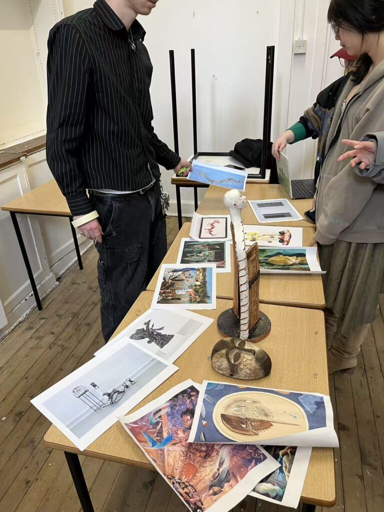
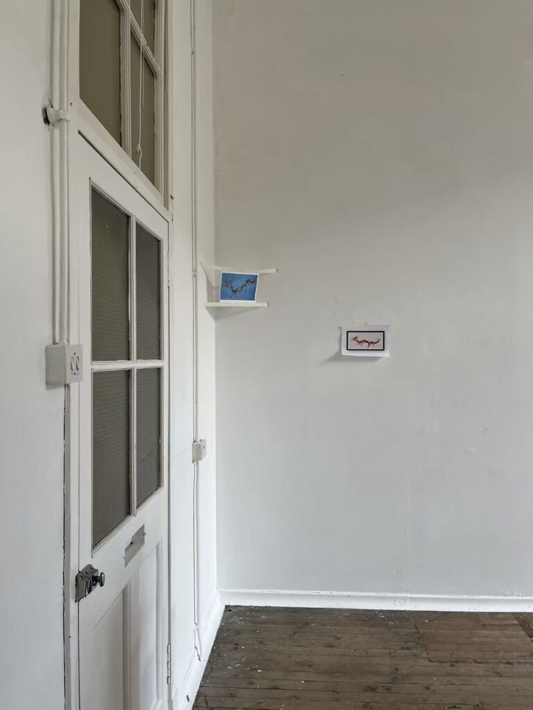
The artistic interventions in this project take the form of co-created, site-responsive development, rather than full, high-cost commissions. The three participating artists may work with the curator to adjust scale, medium, and mode of public presentation according to specific site conditions, allowing the works to respond directly to real issues of speed, duration of stay, visibility, and everyday use in Edinburgh’s public space.

The development process is divided into five stages: initial site visits, route testing, site evaluation, adjustment of intervention intensity, and negotiation of installation method. The works themselves are developed gradually during the project in relation to each site’s spatial conditions, management pressure, and modes of public entry. This both helps control production and delivery costs, and ensures that the generation of the works remains aligned with the project’s method. For the curatorial side, artist development also functions as a mechanism of revision: through collaboration with the artists, questions of site fit, medium choice, and implementation are made more specific, increasing the project’s practical feasibility and responsiveness to the site.

Publication

The project proposes to produce a small English-language publication as an interpretive booklet. It will include the curatorial text, a map of the six sites, artist introductions, route guidance, QR-code entry points, and a short explanation of public feedback. It is intended both as an on-site guide and as a way for viewers to revisit the comparison between spaces after leaving the project. In this sense, it provides this distributed, temporary public project with a further point of entry for rereading.

The publication is both a tool of communication and a light archive. Because the project takes place in public space, many of its key experiences are brief, dispersed, and heavily shaped by environmental conditions. It therefore requires a medium capable of retaining the project’s structure. The publication, the QR-code system, and the later organisation of public feedback are designed to work together, so that after the project ends, there remains a coherent record that can be circulated and revisited. For this project, it functions both as a guide and as an extension of the archive.

References

Artists Union Scotland. “Recommended Rates of Pay (RRoP) 2026–2027.” Accessed April 22, 2026. https://www.artistsunion.scot/recommended-rates-pay-rrop-2026-2027.

Baraitser, Lisa. Enduring Time. London: Bloomsbury Academic, 2017.

Bissell, David. “Animating Suspension: Waiting for Mobilities.” Mobilities 2, no. 2 (2007): 277–98. https://doi.org/10.1080/17450100701381581.

Brauner, Maren, and Irene Grillo. “Walking as a Form of Critical Curating.” OnCurating 8 (2011). https://www.on-curating.org/issue-8-reader/walking-as-a-form-of-critical-curating-1132.html.

City of Edinburgh Council. “Event Planning for Public Spaces.” Accessed April 22, 2026. https://www.edinburgh.gov.uk/downloads/download/16258/event-planning-for-public-spaces.

City of Edinburgh Council. Local Events Open Fund Overview 2026/27. Accessed April 22, 2026. https://consultationhub.edinburgh.gov.uk/sfc/local-events-open-fund-2026-27/supporting_documents/local-events-open-fund-overviewpdf.

City of Edinburgh Council. Public Spaces Fees and Charges 2026/27. Accessed April 22, 2026. https://www.edinburgh.gov.uk/downloads/file/39419/public-spaces-fees-and-charges-2026-2027.

Johanson, Chris. “Chris Johanson.” Mitchell-Innes & Nash. Accessed April 22, 2026. https://www.miandn.com/artists/chris-johanson.

Lothian Buses. Service 35 Timetable. 2025. https://www.lothianbuses.com/wp-content/uploads/2025/02/35_25C04v06.pdf.

National Galleries of Scotland. “Toby Paterson.” Accessed April 22, 2026. https://www.nationalgalleries.org/art-and-artists/artists/toby-paterson.

O’Neill, Paul. The Culture of Curating and the Curating of Culture(s). Cambridge, MA: MIT Press, 2012.

University of Edinburgh. SICP Toolkit. Course document, 2026.

University of Edinburgh. Week 10: Publics & Public Programmes. Lecture slides, 2026.

Ursitti, Clara. “Clara Ursitti.” Glasgow Sculpture Studios. Accessed April 22, 2026. https://www.glasgowsculpturestudios.org/clara-ursitti.

Summative Peer Review of Zhouyi Ding on 18th April

Below is the English translation of your peer review text. I have kept the content unchanged and only rendered it in clear, natural academic English with consistent terminology.

The most obvious strength of the blog is that the project does not move forward mechanically along a fixed path, but instead adjusts its methods actively as it develops. From Week 6 onwards in particular, the author begins to examine pacing, duration, suspension, display, and viewer experience in a more systematic way, and also starts to understand the exhibition as a structure that generates meaning through space, sequence, and viewing conditions. In addition, the actual influence of collective work on the individual project can be clearly traced: the spatial experiment at Summerhall, the practical experience of Our Shell, and observations of moving image display all feed directly back into the SICP, and in turn lead to revisions in structure and display.

One issue that still needs to be clarified across the SICP as a whole is how waiting can actually be experienced by viewers within the exhibition. In Week 4 and the Curatorial Pitch, waiting is divided into three levels: everyday, social/institutional, and existential. This structure helps the project establish a clear conceptual framework. By Week 6, however, the author realises that the layered structure works more as a mode of explanation than as the exhibition process itself. This is where the methodological shift in Week 6 could be developed further. Movement, pause, delay, spacing, and route all need to be written as mechanisms that generate waiting, rather than as supporting forms. In that way, the later Week 7 decisions about work sequence, title, moving image, site, and access could all be brought together around one central question: how does the exhibition bring viewers into a state of time that is prolonged, organised, and endured? Lisa Baraitser’s Enduring Time discusses waiting as a temporal state that is endured, stretched out, and unable to end quickly. This perspective would support the author’s decision to place waiting within pacing and duration. David Bissell’s “Animating Suspension: Waiting for Mobilities” would also be useful for helping the author address the bodily dimension of the exhibition. His account of suspension describes a state organised through pause, rhythmic change, enforced delay, and uncertainty. Bringing this text into the structural adjustments after Week 6 would give stronger grounding to the treatment of route, pause, and bodily experience.

The second issue appears in Week 7. By this point, the relationship between the works and the path has begun to take shape, but the writing still proceeds more through conceptual correspondence than through exhibition function. The problem is not that the works have been selected badly, but that the relationship between them still depends mainly on which type of waiting each one represents. The most effective revision here would be to define more clearly the specific role of each work within the full route: how the opening work changes bodily rhythm and attention as the viewer enters the space; how the works in the middle section organise waiting into a stretched condition through rules, distance, or route; and how the later works leave behind a lingering temporality. In this way, the relationships between the works would move beyond thematic relation and more clearly become experiential relation. Paul O’Neill’s The Culture of Curating and the Curating of Culture(s) would be helpful here, because it supports writing sequence, viewing rhythm, and the organisation of relations between works as curatorial logic rather than simple thematic juxtaposition.

The third issue concerns the entry conditions and display decisions that gradually emerge between Week 8 and Week 12. In Week 8, the author begins to address the title, booklet, and printed matter. In Week 9, threshold, dark-space notice, and access-centred entry are linked to viewing rhythm. By Weeks 10 to 12, the project develops further into site choice, moving image display, floor plan, circulation, and access planning. What now needs strengthening is the compression of these separate decisions into one clearer question: through what kind of entry is the viewer brought into waiting? What kind of entry is already implied by the title Right Here: While Waiting? Within the project, does the booklet function as explanation, guidance, or a delayed interpretive tool? Why are short moving-image works suited to monitor encounters, while longer works require darkened space and seating? What kinds of temporal experience do these two modes of display organise? Once these decisions are written more specifically, title, threshold, display, and access will become more clearly identifiable as parts of the exhibition structure. Beverly Serrell’s Exhibit Labels and Erika Balsom’s Exhibiting Cinema in Contemporary Art would both be useful references here.

References

Baraitser, Lisa. Enduring Time. New York: Bloomsbury Academic, 2017. https://doi.org/10.5040/9781350008151.

Bissell, David. “Animating Suspension: Waiting for Mobilities.” Mobilities 2, no. 2 (2007): 277–98. https://doi.org/10.1080/17450100701381581.

Balsom, Erika. Exhibiting Cinema in Contemporary Art. London: Routledge, 2025. https://doi.org/10.4324/9781003695134.

O’Neill, Paul. The Culture of Curating and the Curating of Culture(s). Cambridge, MA: MIT Press, 2012.

Week 13 – From a Temporary Project to a Sustainable Structure

This week I began to look back at the whole project as a complete structure, rather than simply continuing to add new elements. After constant adjustments to routes, sites, artists, permissions, promotion, and maintenance over the previous weeks, I became more aware that the focus of the project is not how much can be included in the exhibition, but whether these parts can form a curatorial proposal that is internally coherent, accessible, and sustainable.

Looking back at the collective exhibition, I could see many traces of having existed. A short exhibition does not disappear entirely after deinstallation. However, those traces do not automatically become meaningful archives. Only when such records are consciously selected, arranged, and organised can people continue, after the event, to understand the exhibition’s structure, display logic, and public experience. From the curatorial point of view, I therefore came to realise that the afterlife of an exhibition also has to be curated.

This also changed how I understood my own project. I want people to continue to understand how invisible boundaries shape everyday life in Edinburgh even after the exhibition has ended. Because the project takes place in public space and is temporary, it has a strong sense of ephemerality. I therefore treat publication and archive as clearly defined parts of the project’s structure. Their purpose is to ensure that, even after the distributed project has ended, it still retains a form that can be revisited, re-entered, and reinterpreted. I am inclined to design a lighter form of legacy: a small digital archive containing visual records of the six sites, together with electronic content and AR-based visual material, so that viewers can still encounter the route and the sites as visual tools even without the physical works being present.

For me, one very inspiring precedent is Janet Cardiff and George Bures Miller’s Night Walk for Edinburgh. What matters is not only that the work takes place in the city, but that this temporary, time-based viewing experience can continue to be read after the event through its guide and archival materials in the app. This helped me think more clearly about my own project: if my exhibition is temporary and distributed, then its continued existence cannot depend only on memory. It has to depend on those materials that allow the project to be re-entered and reread.

References

Art Fund. “Night Walk for Edinburgh.” 2019.

Fruitmarket. “Night Walk for Edinburgh: Janet Cardiff and George Bures Miller.” 2019.

The Museum of Modern Art Archives. “Archives Exhibitions.”

The Museum of Modern Art Archives. “The Museum of Modern Art Exhibition Records, 1960–1969.”

Week 12 – Publicity, Publics, and Curatorial Communicatio

This week, the most important issue for me was communication. Looking back at our collective exhibition, OurShell, I realized that one of its weaker parts was publicity. We put a great deal of energy into selecting works, installation, and display, but our communication with the public was very limited. The exhibition had only a small impact. Apart from people who already knew about the project or who were already inside Summerhall, we did not attract many other viewers. This made me realize that publicity is an important part of how a project truly becomes public.

This strengthened my thinking about communication in my own curatorial project. I can no longer assume that simply placing works in the city will naturally create meaningful public engagement. Although the project takes place in public space and may appear open by nature, visibility does not automatically mean accessibility. Claire Bishop’s discussion of participatory art was especially helpful for me here. She reminds us that the key issue is not only whether people are physically present, but how they are addressed, invited, and drawn into the project. For this reason, I can no longer assume that a public location alone is enough.

In curatorial practice, publicity needs to be deliberately designed. This is especially true for a project that takes place in an outdoor public space, because an exhibition does not automatically become understandable or noticeable simply because it is placed in the city.

First, as an outdoor project, I need to create more than one “entry point” that can trigger attention and understanding. Rather than relying only on accidental encounter, I want to build a clearer set of communication routes, such as a project map, short introductory texts, and clear on-site prompts. These should allow viewers to quickly recognize what kind of “invisible boundary” each location is exploring. In this way, even if audiences do not enter the project from a single starting point, they can still gain a basic framework for understanding it.

Second, the form of publicity must match the non-linear structure of the project. Since many viewers may only encounter one or two sites rather than the whole exhibition, each communication element must be able to function independently, instead of relying on the complete route to make sense. Different sites, therefore, need different forms of communication and prompting. In highly mobile areas such as Princes Street and Waverley Bridge, viewers are likely to stop only briefly, so concise and direct short texts are more suitable. These can quickly signal what kind of boundary is being discussed. Royal Mile is shaped more strongly by tourist attention, so clearer on-site prompts can help viewers recognize that this street is not only a cultural image, but also a public space constantly reshaped by consumption, performance, and the tourist economy. Holyrood Park has a slower rhythm, and audiences may stay longer, so it can support a more reflective form of interpretation. Slightly longer texts or prompts that emphasize the relationship between landscape and public use would be more appropriate there. Leith Walk and Ocean Terminal are closer to everyday community life, so the communication there needs to connect more directly with residents and regular passers-by, and to highlight differences in the way space is used.

Third, I need to think more carefully about who the project is actually for. Nina Simon argues that the relevance of a cultural project depends on how it connects with the lived experience and real concerns of its intended publics. For me, this means I can no longer treat “the public” as one vague category. I need to distinguish more clearly between residents, passers-by, commuters, and visitors. Residents are more likely to feel how tourism, commercial use, and spatial control gradually affect their sense of belonging, so the project needs to create stronger forms of recognition and emotional connection for them. Passers-by may only stop for a short moment, so the sites need immediate and clear visual or textual points of entry. Commuters are often under time pressure, which means the project must also allow for fragmented and brief engagement. Visitors, meanwhile, may be more willing to explore, but they often experience Edinburgh through familiar routes and accepted city images, so the project also needs to interrupt and reorganize those ways of seeing. Seen in this way, publicity is not simply about helping more people “see” the exhibition, but about allowing different publics to enter the project in different ways.


References

Bishop, Claire. Artificial Hells: Participatory Art and the Politics of Spectatorship. London: Verso, 2012.

Cardoso, Kristen. Review of Book Review: The Art of Relevance, Written by Nina Simon. Weave (Ann Arbor, Mich.) 1, no. 6 (April 2017). https://doi.org/10.3998/weave.12535642.0001.605.


Week 11 – Collective Display, Material Decisions, and Curatorial Responsibility

This week, through reflection on our collective curatorial practice, I gained a great deal of valuable practical experience, which also led me to reconsider the relationship between exhibition concept and exhibition making. During the installation process at Summerhall, I came to understand very directly that exhibition production is never only a matter of choosing a theme and placing works. It also involves using display planning, material selection, and spatial arrangement to realise ideas in a layered and coherent way, and this process inevitably involves problems and compromises.

Our main question was how to create coherence among works that differed greatly in style, size, form, and medium. We tested several display arrangements and repeatedly abandoned earlier plans. Through these discussions, I began to understand that display itself forms part of the curatorial argument. The distance between works, the sequence in which works enter the viewer’s field of vision, and the arrangement of different media all directly affect how viewers understand the relationship between individual works and the exhibition theme as a whole.

Installation view of Our Shell, showing painting display with suspended labels
Installation view of Our Shell, showing painting display with suspended labels, Summerhall, Edinburgh, 2026. Photograph by Hazel Ren.


Installation view of Our Shell, showing hanging label design in relation to the gallery doorway, Summerhall, Edinburgh, 2026. Photograph by Luosijie Ding.


Installation view of Our Shell, showing suspended photographic display with red thread intervention, Summerhall, Edinburgh, 2026. Photograph by Hazel Ren.


Installation view of Our Shell, showing garment installation and wall arrangement, Summerhall, Edinburgh, 2026. Photograph by Hazel Ren.

The experience of the collective also made me reflect on my own project. Because the exhibition is distributed across the city, the relation between the sites needs to operate in two ways: first, as an overall structure; second, as something that still has value when a single site is encountered on its own. Whatever order of entry is taken, the overall experience should remain intelligible. I therefore need to pay closer attention to how to design a structure that can still function even when it is experienced unevenly. In this context, curatorial mediation becomes important. If the order of viewing cannot be fully controlled, then the map, site texts, and AR prompts need to take on the task of creating links between parts.

As the project moves from spatial judgement towards actual configuration, I have also become more aware that public-space display is never only a matter of where works are placed. It is also about how they are maintained. The six sites cannot simply be installed once and then assumed to work on their own. Works, boards, QR devices, and feedback points all need to be checked, maintained, and reset during the period of display. Maintenance, therefore, becomes part of curatorial responsibility, because if a public project cannot sustain legibility, accessibility, and basic integrity, then its spatial judgement cannot really stand. The experience of a framed work being damaged during transport in the collective exhibition also confirms this. Curating is never only the visible act of display. It necessarily includes the risk management and responsibility that takes place behind the scenes.

references

Kwon, Miwon. One Place after Another: Site-Specific Art and Locational Identity. Cambridge, MA: MIT Press, 2002.

O’Neill, Paul. The Culture of Curating and the Curating of Culture(s). Cambridge, MA: MIT Press, 2012.

University of Edinburgh. “IMPORTANT 2026 Toolkit BLOGs and Speculative Individual Curatorial Projects.” Course document.

“Walking as a Form of Critical Curating.” OnCurating, no. 8. Accessed April 13, 2026.

Week 10 – Urban Conditions, Mobility Strategies, and Degrees of Intervention

This week I examined the project again in relation to the real conditions of Edinburgh. The exhibition strategy for public space cannot rely only on a single route. It has to be adjusted according to spatial density, systems of management, and patterns of movement. In other words, the question becomes how the exhibition can actually take shape under different urban conditions.

Tourist activity is concentrated in the city centre, especially around Princes Street, Royal Mile, and Waverley Bridge, all of which are marked by high footfall, high consumption, and high visibility. By contrast, Leith Walk, Ocean Terminal, and Holyrood function more as spaces of local everyday life. On this basis, I adjusted the mobility strategy. The earlier plan of linking all sites by bus is not appropriate in high-density areas, where it would increase transport pressure in already crowded conditions. Princes Street, Royal Mile, and Waverley Bridge are therefore now connected by walking, without direct use of the bus system. Holyrood, Leith Walk, and Ocean Terminal still retain the 35 bus as a link during off-peak hours. Because buses are already heavily used in Edinburgh—with Lothian Buses carrying over 100 million passengers each year—avoiding peak times is necessary. At the same time, the project still treats movement as a curatorial condition, so I have not removed the bus completely, but instead limited it to the 10am–4pm off-peak period. The shift between walking and bus travel can itself become part of how audiences understand spatial difference in the city.

The pedestrian routes in high-density areas do not involve steps, so they are fully suitable for wheelchair access, while the 35 bus offers connection across the lower-density sites without creating extra burden for viewing.

Street view of the Royal Mile, documenting the high-density pedestrian environment of the city centre during route testing. Photograph by Hazel Ren, March 2026.
Street and tramline view of Leith Walk, documenting a lower-density urban condition and transport-linked route connection. Photograph by Hazel Ren, March 2026.
Bus 35 digital stop display, documenting route timing and off-peak public transport conditions during fieldwork. Photograph by Hazel Ren, March 2026.

This adjustment also made the relationship between artists and sites clearer. Toby Paterson suits Princes Street because the issue there lies in how commercial frontage, pedestrian flow, and urban surfaces organise movement and looking. Holyrood Park does not require a stronger visual centre, so Clara Ursitti’s sensory intervention is more appropriate. Her work can draw viewers out of the compressed speed of the city centre and make entry into space slower and more bodily aware. Leith Walk is better suited to Chris Johanson’s text-based or light graphic intervention, because the issue there is not tourist spectacle, but the continuing relations between stopping, passing through, watching, and being overlooked within everyday circulation.

I also looked at precedents for linking transport and culture in Edinburgh. Travelling Treasures embedded cultural content into transport experience, making movement itself part of the narrative. Fringe Days Out used buses to enable more community groups to take part in cultural events. Both cases suggest that public transport can function not only as infrastructure, but also as a means of cultural organisation and public connection.

Because the project uses a graded intervention strategy in relation to permission, activities are matched to spatial conditions. Low-intensity interventions such as walking, QR codes, signage, and non-gathered experiences are more easily aligned with ordinary spatial use. Medium-intensity interventions require case-by-case evaluation. High-intensity activities such as performance or clear forms of gathering require formal permission. At present, everything in the project is low-intensity except for the slow-walk performance at Royal Mile.

References

City of Edinburgh Council. “Use of Public Spaces for Events and Filming Policy.” October 5, 2023. https://democracy.edinburgh.gov.uk/documents/s61901/Item%207.3%20-%20Use%20of%20Public%20Spaces%20for%20Events%20and%20Filming.pdf.

City of Edinburgh Council. “Use of Public Spaces for Events and Filming: Final Report.” May 11, 2023. https://democracy.edinburgh.gov.uk/documents/s57266/8.3%20-%20Use%20of%20Public%20Spaces%20for%20Events%20and%20Filming_Final.pdf.

Edinburgh Festival Fringe Society. “Fringe Days Out.” Accessed April 16, 2026. https://www.edfringe.com/experience/school-and-community-engagement/school-and-community-projects/fringe-days-out/.

Edinburgh Festival Fringe Society. “Fringe Days Out Returns in 2024 to Help Edinburgh Communities Engage with the Fringe.” April 30, 2024. https://www.edfringe.com/about-us/news-and-blog/fringe-days-out-returns-in-2024-to-help-edinburgh-communities-engage-with-the-fringe/.

Le Lieu, centre en art actuel. Manœuvres – Le Lieu, centre en art actuel. Edited by Richard Martel. Dijon: Les presses du réel, 1992. Accessed April 16, 2026. https://www.lespressesdureel.com/EN/ouvrage.php?id=2298&menu=0.

Lothian Buses. “Public Transport Use in the Capital Continues to Grow.” January 9, 2026. https://www.lothianbuses.com/news/2026/01/public-transport-use-in-the-capital-continues-to-grow/.

Lothian Buses. “Lothian City Buses: Service 35.” Accessed April 16, 2026. https://www.lothianbuses.com/our-services/lothian-city-buses/.

Week 9 – Testing Non-Linear Viewing and Rethinking Publics

This week I carried out a site visit of the full route and reconsidered the structure. Although the six-site model had already been designed to move away from the control of a single path, in curatorial terms it still depended on the assumption that viewers would be able to complete all the sites in sequence. A viewing process of more than four hours made two issues very clear: the route was too long, and the structure still relied too much on the logic of “complete viewing”.

I therefore had to reposition the role of the full route within the project. My decision was to treat it only as the most intensive mode of entry, while also introducing shorter route combinations and fragmented entry. This would allow viewers to enter through the map, choose their own path, and decide how long to stay. The deeper purpose of this change was to make the viewing structure more consistent with the real use of urban space. Entry is often incomplete, pauses are often accidental, and movement is shaped by time, stamina, interest, and transport. Non-linearity therefore became an explicit methodological judgement: the viewer’s own choice is itself part of the argument of the project.

This also led me to rethink the issue of guidance. The project cannot simply leave viewers to explore at random, otherwise the critical framework becomes too weak. But it also cannot tightly direct every step, otherwise it repeats the very spatial management logic it seeks to question. I therefore began to move towards a structure that is partly guided and partly open. Key sites provide prompts and frameworks, while other parts leave room for viewers to connect experiences themselves. In this model, walking matters because it organises perception and allows judgement to emerge through movement. The route is no longer a simple tool linking sites, but one of the project’s actual curatorial structures.

This week I also clarified my thinking on publics. What matters more in the project is not which fixed identity category a viewer belongs to, but how they enter the route, how long they stay, how quickly they move, and whether they can bring the dispersed site experiences into some kind of coherent understanding. Publics therefore no longer appear as a pre-existing whole, but as positions formed through the interweaving of viewing, entry, and judgement. This gives the non-linear structure a clearer methodological meaning: it responds not only to social identity difference, but also to how time, mobility, and modes of spatial use shape the conditions under which publics enter the work.

References

Brauner, Maren, and Irene Grillo. “Walking as a Form of Critical Curating.” OnCurating, no. 8. Accessed April 16, 2026. https://www.on-curating.org/issue-8-reader/walking-as-a-form-of-critical-curating-1132.html.

Le Lieu, centre en art actuel. Manœuvres – Le Lieu, centre en art actuel. Edited by Richard Martel. Dijon: Les presses du réel, 1992. Overview accessed April 16, 2026. https://www.lespressesdureel.com/EN/ouvrage.php?id=2298&menu=0.

Lippard, Lucy R. The Lure of the Local: Senses of Place in a Multicentered Society. New York: New Press, 1997.

VisitScotland. “Edinburgh and the Lothians.” Accessed April 16, 2026. https://www.visitscotland.org/research-insights/regions/edinburgh-lothians.

Week 8-From Proposal to Production

This week the project began to shift from a set of separate ideas into a structural problem. The real question was no longer how to add more content, but whether the parts already in place could be organised into a sequence that others could enter and read. In my case, the six sites, routes, interpretive tools, and public materials all have to be designed as one integrated system of reading.

The week’s discussion of archives and exhibition history helped me think this through more clearly. In her work on “remembering exhibitions”, Reesa Greenberg argues that the reappearance of an exhibition does not mean bringing the past back intact, but reorganising experience through forms such as replica, riff, and reprise. This was important for my project because what I am examining is not a one-off event, but a spatial structure that recurs across the city. Routes, stopping points, entrances, and patterns of use all form their own order within everyday practice. What curating can do, then, is rearrange these naturalised traces so that they no longer operate simply as background.

This also forced me to correct my own language. “Outdoor wandering” is not accurate enough. The project is closer to an organised critical route than to wandering in any simple sense. That matters to me because the route is one way in which the project argues for its own question. Viewers do not first see the works and then understand the route; the route itself actively shapes how they understand both the works and the city

Production checklist and early booklet sketch for the Summerhall collective event. Photograph by Hazel Ren, March 2026.

The collective practice at Summerhall also made me aware of another issue: publics do not begin with the work itself. Posters, pamphlets, layout, and spatial sequence all influence the way viewers first approach a project. Promotion and entrance design, therefore, have to be taken seriously. This also led me back to my own project: the six sites cannot be linked merely through thematic similarity. Their relation has to be concretely supported through maps, on-site texts, booklets, and other devices, so that the project can truly function as a readable whole.

References

Brauner, Maren, and Irene Grillo. “Walking as a Form of Critical Curating.” OnCurating, no. 8. Accessed April 16, 2026. https://www.on-curating.org/issue-8-reader/walking-as-a-form-of-critical-curating-1132.html.

Greenberg, Reesa. “Archival Remembering Exhibitions.” Journal of Curatorial Studies (BRISTOL) 1, no. 2 (June 2012): 159–78. https://doi.org/10.1386/jcs.1.2.159_1.

Lewis Jacob, Adam. Underground, Overground, Inside and Out: Exploring the Dynamics of Artist-Run Spaces. MA Contemporary Art Theory: Curating course presentation, University of Edinburgh, 2026.

Week 7 – Finalizing the Title and Revising the Funding Logic

This week, I focused on two questions: how can the title clearly reflect the argument of the exhibition, and how can the budget move from an idealised figure to a realistic funding logic?

After discussions with my tutor and group members, I finalised the title Whose Space? Invisible Boundaries in Edinburgh’s Public Life. I became more certain that a title should not aim for obscure metaphor, but should allow a first-time reader to grasp the content and direction of the project.

The budget needed deeper work. An initial upper figure of around £10,000 forced me to distinguish between what is genuinely necessary and what still remains at a conceptual stage. Three artist residencies, several commissions, a complete AR system, public events, security, and documentation all seemed reasonable when taken separately, but clearly too large when placed within the framework of an emerging curator’s project. I therefore had to prioritise those elements that most directly support the argument of the exhibition: site interpretation, basic accessibility measures, essential documentation, and AR as a key interpretive tool. Because of cost, AR cannot be developed as a full-route system. Instead, it needs to be retained as an interpretive device for only a small number of key sites. Princes Street and Waverley Bridge are the most suitable places for this, because they most clearly show how commercial visibility and infrastructural movement shape spatial use. Other sites can instead be addressed through performance or rhythm-based interventions. The result is that AR remains central, but with a more clearly defined role: it serves spatial interpretation.

In terms of funding routes, the City of Edinburgh Council’s Local Events Open Fund currently appears the most suitable primary option. The Council’s 2026/27 overview shows that the fund is divided into three bands—£20,000, £12,000, and £5,000—and gives priority to commitment to communities, environmental responsibility, fair work, and equality, diversity and inclusion, while supporting activities with public cultural value in Edinburgh. A strong supplement to this is Creative Scotland’s Open Fund for Individuals, which supports research, development, and project delivery, with grants between £500 and £50,000.

I also researched local precedents in Edinburgh related to public-space commissions. The Council’s grant register specifically mentions the Edinburgh Art Festival – New Waverley Commission 2017 project, aimed at producing a work that directly responded to the New Waverley environment. The Edinburgh Art Festival 2017 Commissions Programme also describes its publicly sited works as opening overlooked urban spaces. This shows that site-responsive, public-facing commissions connected to specific city environments are not exceptional or unimaginable within Edinburgh. Even though my project remains a speculative proposal, it is not detached from the reality of the city.

References

City of Edinburgh Council. “Local Events Open Fund 2026/27.” Accessed April 16, 2026. https://consultationhub.edinburgh.gov.uk/sfc/local-events-open-fund-2026-27/.

City of Edinburgh Council. Local Events Open Fund Overview. Accessed April 16, 2026. https://consultationhub.edinburgh.gov.uk/sfc/local-events-open-fund-2026-27/supporting_documents/local-events-open-fund-overviewpdf.

City of Edinburgh Council. “Live Grant Register.” Accessed April 16, 2026. https://www.edinburgh.gov.uk/downloads/file/38021/grant-register.

Creative Scotland. “Open Fund for Individuals.” Accessed April 16, 2026. https://www.creativescotland.com/funding/funding-programmes/open-funding/open-fund-for-individuals.

Culture & Business Scotland. “C&BS Fund.” Accessed April 16, 2026. https://cultureandbusiness.scot/cbs-fund/.

Edinburgh Art Festival. “Edinburgh Art Festival 2017 Commissions Programme.” Accessed April 16, 2026. https://www.edinburghartfestival.com/edinburgh-art-festival-2017-commissions-programme/.

University of Edinburgh. Week 7 SICP Toolkit. MA Contemporary Art Theory: Curating course document, 2026.


Week 6 – From Proposal to Spatial Testing

After the curatorial pitch, the project entered a testing phase, which raised a basic question: once the exhibition enters real urban space, can its original structure still hold? Public space is not a neutral display container. Its use is always shaped by systems of management, pedestrian flow, and architectural environment, so curatorial form itself must be reshaped by real conditions. This week, therefore, my work focused on spatial testing. For a project structured around six public sites, permission becomes a crucial issue. It is one of the clearest and most direct expressions of spatial power, because it reveals how a place is organised, restricted, and made accessible to different people.

This also pushed me to rethink the place of “intervention” within the project. Simply bringing works into the city is not enough to produce an effective intervention. It has to be able to interrupt patterns of use that have already been accepted as normal, so that a naturalised spatial order reappears as something constructed. The Situationist International provided an important reference here, especially through its discussions of dérive and psychogeography, which examine how the city organises perception and action through flow, function, and rhythm. Marcus Jack’s classroom use of Debord’s statement that “all that was once directly lived has become mere representation” was also important for me, because my project deals with a similar spatial reality: some places appear natural only because the inequalities within them have been repeated so often that they are no longer questioned. In that sense, the value of intervention is not to create a visual event, but to disturb existing spatial relations.

The collective spatial test at Summerhall gave me a further insight. Shared themes do not automatically produce coherence. The distances between works, the order in which they enter the viewer’s field of vision, and the arrangement of different media all directly affect how the exhibition is understood. Adjustments to the position of video, installation, and painting were therefore not minor technical matters, but ways of constructing the inner logic of the exhibition. The lesson for my personal project was clear: the six sites cannot be treated as six separate statements, but must form a rhythm and set of relations that can be genuinely perceived.

Collective discussion and artwork grouping during the first offline setup at Summerhall, March 2026. Photograph by Hazel Ren.
Early wall arrangement test during the collective setup at Summerhall, March 2026. Photograph by Hazel Ren.
Initial spatial test during the first offline collective setup at Summerhall, March 2026. Photograph by Hazel Ren.

References

Han, Shuyan, Dexuan Song, Leiqing Xu, Yu Ye, Shurui Yan, Feng Shi, Yuhao Zhang, Xiaodong Liu, and Hu Du. “Behaviour in Public Open Spaces: A Systematic Review of Studies with Quantitative Research Methods.” Building and Environment 223 (September 2022): 109444. https://doi.org/10.1016/j.buildenv.2022.109444.
Chitrakar, Rajjan M, Douglas C Baker, and Mirko Guaralda. “How Accessible Are Neighbourhood Open Spaces? Control of Public Space and Its Management in Contemporary Cities.” Cities 131 (December 2022): 103948. https://doi.org/10.1016/j.cities.2022.103948.

Lewis Jacob, Adam. Underground, Overground, Inside and Out: Exploring the Dynamics of Artist-Run Spaces. MA Contemporary Art Theory: Curating course presentation, University of Edinburgh, 2026.

University of Edinburgh. Week 6 SICP Toolkit. MA Contemporary Art Theory: Curating course document, 2026.