Any views expressed within media held on this service are those of the contributors, should not be taken as approved or endorsed by the University, and do not necessarily reflect the views of the University in respect of any particular issue.
Digimap is an online map and data delivery service, available by subscription to UK Higher and Further Education establishments. Operated by EDINA at the University of Edinburgh, Digimap offers a number of data collections, including Ordnance Survey, historical, geological, aerial photography, LiDAR, marine maps, land cover mapping, global mapping and census data. For more information about Digimap go to our website: https://digimap.edina.ac.uk Background image Contains OS data (c) Crown Copyright and database right 2022
The VectorMap Local (VML) maps mentioned in the previous blog posts are now working in Digimap Roam. There is a video on YouTube showing you how to view all the different mapping styles that are now available at the four most zoomed in levels; including all the VML maps and Land-Line style MasterMap:
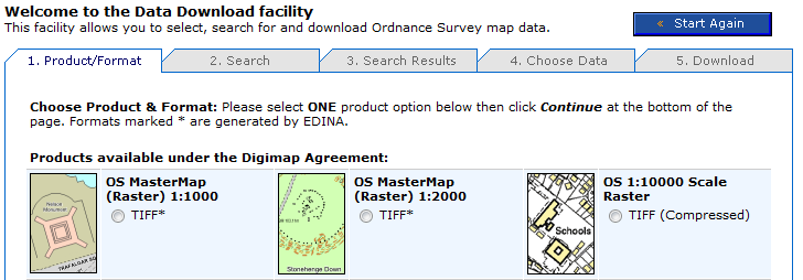
OS MasterMap data is now available to download in a rasterised (image) format from Digimap’s Data Download facility. If you need an image of OS MasterMap data (for example, as a backdrop map) but don’t need the complexity of the original vector data, this new stuff is for you.
OS MasterMap – detailed but complex
OS MasterMap is the most detailed product offered by Ordnance Survey. Maps made with with OS MasterMap have been available through Digimap’s mapping facilities since 2007, but if you wanted to use OS MasterMap as background for a customised map by overlaying your own data in a GIS you needed to download and convert the raw GML data. If all you want is a detailed colour background image, this seems like a significant investment of time.
Rasterised OS MasterMap – images not data
Digimap now offers OS MasterMap as .tif images at two scales: 1:1000 and 1:2000 through the usual Data Download facility. This saves you having to download, convert and import the data using specialist GIS software.
Where do I get the OS MasterMap raster background maps?
Log in to Digimap’s OS Collection, go to Data Download and select which scale of OS MasterMap image you want from the list of products. The images are tiled in 1km square tiles, so you can select your area of interest, and the tiles covering it, in the same way as other tiled datasets.
The scales are determined according to the distance on the ground represented by each pixel. The larger scale images are based on a measurement of 0.3125m per pixel. The smaller scale images are based on a measurement of 0.625m per pixel. These equate to approximate scales of 1:1000 and 1:2000 respectively, although these are dependent on the screen resolution of your monitor. You can easily display the maps at other scales, but some loss of image quality may occur if you do.