Other work
SENSE Research Experience Placement
Supervising undergraduate students on the SENSE research experience placement for summer 2021.
Poverty Estimates in Mozambique and Zimbabwe Using High Resolution Satellite Data
Supervisors: Dr Gary Watmough , Peter Hargreaves
Institute: University of Edinburgh
Department: Geospatial Livelihoods Group, School of Geosciences.
Rationale: The UN high-level panel on post-2015 development goals called for a ‘data revolution’ to help overcome the poor quality of statistical data available in developing countries. However, most countries cannot afford to increase the number of surveys that they conduct to track all aspects of the Sustainable Development Goals. The Geospatial Livelihoods Group at the University of Edinburgh are working on several projects to examine how very-high spatial resolution satellite data could be used to update poverty estimates when survey and census data are not available. Earth Observing Satellites have been collecting imagery of the Earth’s surface since 1972. We examine how satellite data could be linked with household and census datasets to provide information on socioeconomic conditions. This internship project would work with Dr. Gary Watmough and Peter Hargreaves (3rd year PhD student) to support analysis in Mozambique and Zimbabwe. Tasks would include: (1) using existing land cover classification process trees developed in Mozambique and Zimbabwe to classify new imagery; (2) using an Object based image analysis approach applied to 50cm resolution satellite data in to identify building footprints and classify the building roof materials (3) linking these to survey data available for the regions.
—–|
Course development
Satellite Data for Sustainable Development Goals – with Gary Watmough and Iain Woodhouse, I helped to produce an online credit-bearing course as part of the Edinburgh Futures Institute DSTI Initiative. This course is running for a second time in May 2022, please see the course website for more information.
“This course examines how satellite data of the Earth can be used in the context of Sustainable Development Goals, and the easy-to-access tools that can be used to apply such data to practical SDG issues (such as monitoring and reporting). It starts with an introductory overview of the principles of remote sensing from space, and the narratives, and origin, of SDGs. It considers the operational elements of monitoring, such as completeness of data, uncertainties and costs, as well as introducing students to the practical use of satellite data, using Earth Blox. Earth Blox is a data analytics tools that has a shallow learning curve, giving students quick access to global EO data. Earth Blox is a new web-based tool, so it requires no local installation or specialised computing hardware. The bulk of the course looks at 4 SDGs in particular (2, 11, 13, 15), as the easiest examples of how EO data can be used to inform decision makers, or contribute to the broader SDG narrative.”
—–|
Very high-resolution mapping of urban building density for COVID-19 Social Distancing
I undertook a short-term research assistant position between April and July 2020 on a Scottish Funding Council SFC-GCRF COVID-19 Rapid Response Grant. Based in southern Zimbabwe, the project was titled ‘Using geospatial data and techniques in response to COVID-19 social distancing requirements in Bulawayo, Zimbabwe’. We used very high-spatial resolution (VHR) satellite imagery and geospatial data to rapidly map and identify challenging areas, with the aim of informing municipal planning and facilitating interventions for the City of Bulawayo. My role entailed supporting the development of object oriented rulesets to segment and classify the VHR satellite imagery of the city.
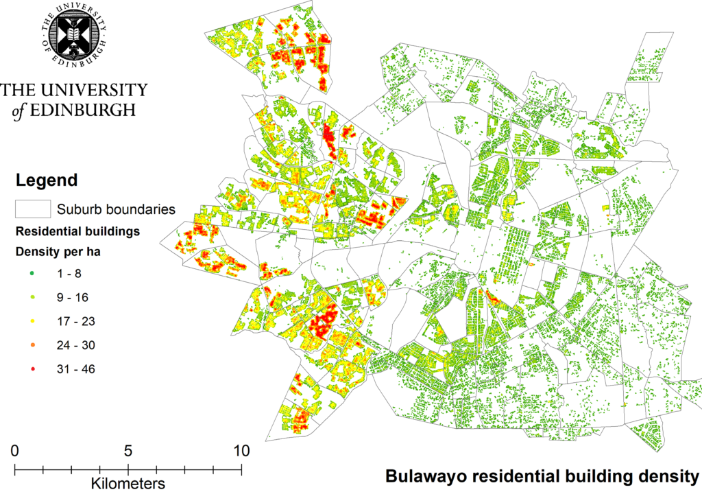
The number of residential buildings per hectare for suburbs across Bulawayo (produced by Dr. Lesley Gibson).
The main outputs of the project were residential building density maps (above). We were working with the municipal government who identified that the high density areas coincide with the incidence of poorer households. At the same time there is a very high chance that high building density areas correspond with high populations of people. This has important implications for social distancing implementation given the greater risk of viral transmission.
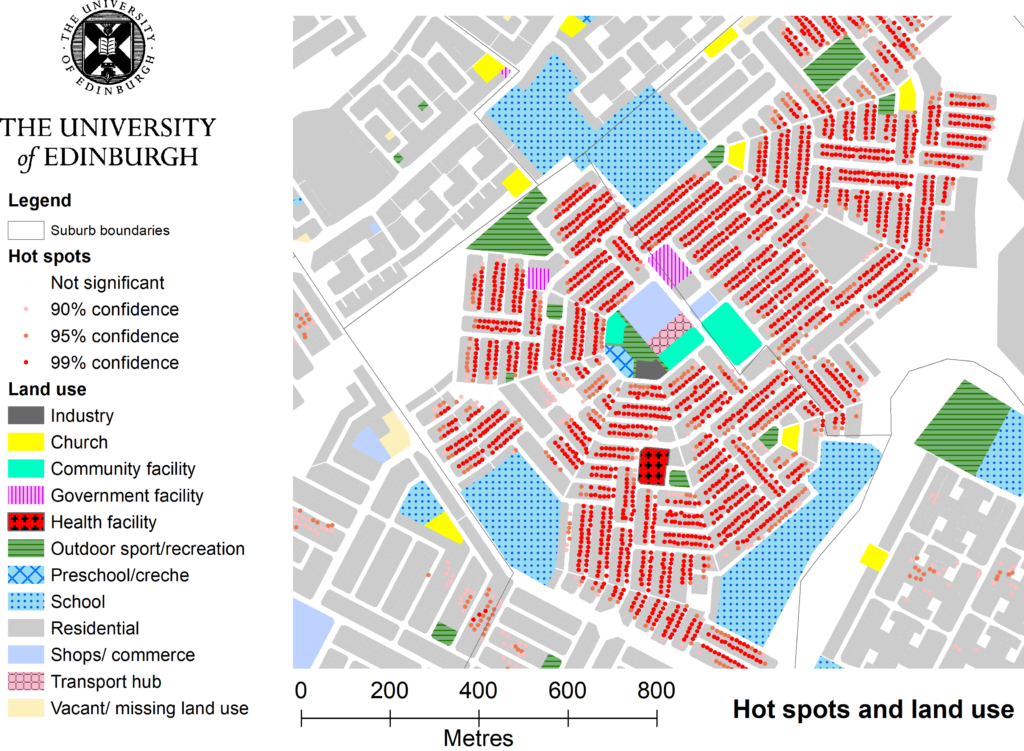
Hotspot analysis of COVID incidence for a ward in Bulawayo. (Produced by Dr. Lesley Gibson)
Further, by overlaying OSM building data onto the up-to-date VHR imagery we found that some regions of the city had new buildings. This confirmed reported patterns of rural-urban migration, and it is an important factor to consider when updating and validating the risk maps for the city.
You can find more details on this project here or you can get contact in via my details on the Greetings page.
Comments are closed
Comments to this thread have been closed by the post author or by an administrator.