My research on natural flood management (NFM) has focussed on the role of land cover in controlling rapid runoff in river catchments. I’ve used a range of hydrological monitoring and analysis method, based on hydrometric, isotopic, geochemical, geophysical and GIS data to investigate questions at hillslope to catchment scales.
Role of land cover in controlling rapid surface runoff during storms
In this research I have investigated the relative roles of land cover and soil type on controlling rapid storm runoff. I compared three sub-catchments of the Eddleston NFM pilot (Middle Burn, Shiplaw and Longcote – all ~ 3km2) to determine the proportion of surface rainfall runoff, soil water and groundwater in streamflow during different storm events. Detailed fieldwork was undertaken during storm events to monitor temporal variability in stable isotopes 2H and 18O in rainfall and streamflow, and Acid Neutralising Capacity (ANC) in streamflow. These data enable to sources of water during the events to be investigated.
The results (Peskett et al., 2021) indicate that pre-event water stored in soil and groundwater is an important component of stream discharge during storms for these small catchments (10 km2). Geology and soil type appeared to exert a stronger control on the fraction of event water compared to the extent of plantation forest cover – demonstrating the importance of the hydrogeological environments in flood generation.
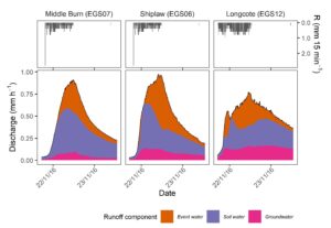
Three-component hydrograph seperation based on stable isotopes in streamflow and rainfall and ANC in streamflow relative to baseflow conditions. Much of the streamflow comprises pre-event water stored in the catchment, with the greatest proportion soil water (Peskett et al. 2021). The Longcote catchment with limited glacial till, and more bedrock exposed, shows a slower response during storm events and a greater proportion of groundwater within streamflow.
Impacts of field boundary planting on hillslope groundwater dynamics
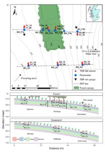
In this research I have instrumented a mixed woodland forest strip on a field boundary to investigate its impact on hillslope runoff. The research has used soil moisture sensors, groundwater sensors and repeat geophysics to understand the dynamics over different timescales compared to a field of improved grassland. The monitoring identified significant differences in sub-surface moisture dynamics underneath the forest strip: drying of the forest soils was greater, and extended deeper and for longer into the autumn compared to the adjacent grassland soils (Peskett et al. 2020). However downslope of the forest, soil moisture dynamics was similar in the forest and grassland transects and no significant effect was recorded 15 m downslope of the forest. Groundwater levels in the forest strip were persistently deeper than the grassland and this effect was observed downslope of the forest strip. However, during the wettest conditions, the monitoring indicated upslope-downslope water table connectivity beneath the forest with response times similar for grassland and the forest transect. This research suggests that fragmented forest strips have little impact on groundwater connectivity within a catchment during wet periods, although further research in a variety of different geological environments is needed.
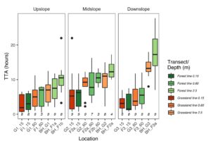
Time to response from the start of rainfall (TTR) for uplsope, midslope and downslope for the forest strip and grassland transects for the 9 wettest events where the monitoring network responded to rainfall. G refers to grassland strip, F for forest, BH is piezometer and 15 and 60 refer to soil mositure at 15 cm and 60 cm respectively. In each domain shallower sensors respond quickest to rainfall. Groundwater response time increases with distance down slope, but with no statistical difference between the grassland and forest strip (Peskett et al. 2020). Reprinted from Journal of Hydrology, 581, 124427 © 2020, with permission from Elsevier