Undergraduate Geological Mapping Project – Isle of Kerrera

Written by Brandon Hattam, BSc Geology
At the beginning of June, I spent an incredible 5 weeks on the Isle of Kerrera for my undergraduate geological mapping project, with the task of producing a geological map of the whole island.
The undergraduate geological mapping project is the basis of my dissertation for my degree in Geology, which is now titled Earth Sciences. This is where a student spends a minimum of 28 days geological mapping in a field area of their choosing. For the older Geology degree programme, this was the only type of dissertation project available. For Earth Sciences, there is a choice between a mapping dissertation and a lab-based one.
If given the choice today, I would still take a mapping project! Personally, I find the approach to be very relaxed and enjoyable (as I do love the outdoors). It also allows a student to complete a solid 40% of their dissertation project before September.
Deciding to map the Isle of Kerrera was part of a long process. To decide a good mapping area, one must consider many factors, such as cost, travel, food availability, accessibility, accommodation and the overall geology!
Everyone has different circumstances, so picking the right area is very important. For me, cost was the biggest factor to consider. Myself and my mapping partner and I looked at many places before deciding on Kerrera, which was the perfect place for both of us.
We also had to make sure to research the underlying geology and exposure on the island before committing to it. We quickly found that it was a hotspot for undergraduate dissertation projects!
Beforehand, we also had to research how we would get to a supermarket and how we would traverse the island. These were also key in making sure we weren’t going to be immediately stuck.
Learn more about my top tips for choosing a dissertation subject in geosciences
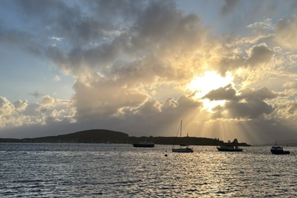
The Isle of Kerrera, taken from the promenade in Oban.
The Isle of Kerrera
The 12.14 km² island had a fascinating mix of geological units. The Easdale Slate Formation is a beautifully folded Dalradian slate, a metamorphic rock, that I find to represent ancient ocean sediment, turned into these rocks and then folded by the closure of the same ocean. These were unconformably overlain by the Kerrera Sandstone Formation. These are Devonian sedimentary rocks, such as sandstones, breccias and conglomerates. An unconformity is essentially “missing geological time” where erosional processes cut into an older rock, before younger rock is formed on top. Here, the time between the Dalradian and Devonian is around 100 million years!
A strip of a volcanic unit of basalt to the east and at some south-western peaks was also present on the island. These basalts are inferred to have been brought down by faulting, a tectonic process that displaces rock, potentially during the same event that formed the Great Glen Fault (look at a map of Scotland, and you will see a large line trending south-west from Inverness)!
Andesite was also dotted in a couple of locations. These are referred to as the Lorn Plateau Volcanic Formation, also Devonian age. All of these units were cut by Tertiary-age dykes from the North Britain Palaeogene Dyke Suite. Dykes are igneous intrusions that cut into rock units. Alongside more evidence of faulting and some clear Quaternary glacial processes, this allowed for a mapping project that was both interesting and challenging.
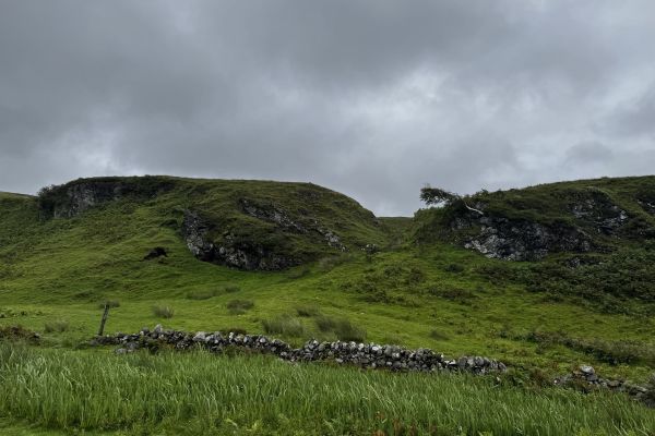
The Lorn Plateau Volcanic formation (basalt) that I walked past countless times to and from my accommodation.
The geological mapping project
Mapping the geology of an entire island sounds daunting, especially in 5 weeks; but luckily, I was able to successfully finish the field work. This included both positives and some negatives.
When you are doing fieldwork for any length of time, you must be prepared to face the elements. Kerrera is on the west coast of Scotland, which happens to be a section of “Celtic Rainforest”! This meant typical days were always a bit rainy and humid, but after doing fieldwork in Inchnadamph last year, I was used to this!
A couple of days had torrential rain and annoyingly had to be avoided, but I accounted for that in my time booked at my accommodation. With 28 days minimum of fieldwork needed, I had 7 days extra for days off.
My mapping partner and I stayed in a small cabin on the south side of the island. It had just about everything we needed for the 5 weeks: induction hobs, a fridge, a shower, etc. We were also very lucky to have a very generous host who let us use their clothes washing facilities, which was necessary when doing 5 weeks of field work. He was also kind enough to drive us to Oban on most of our food shopping days, making the 1.5-hour journey by foot to Oban a lot less common.
On the topic of food, we had a small fridge between the two of us and no freezer. This meant we had to be smart with planning our meals and choosing what perishables we bought back to the island. That was a learning curve for me, as in Edinburgh I live next to a supermarket and get the luxury of buying what meals I want on the day. Planning out a shopping list and working out what to eat based on use-by dates was a good skill to develop. In the event of a sudden need for extra food, there were two small farm shops on Kerrera, with an honesty box payment system. We luckily never went hungry!

Left: A stream, cutting into slate on southern Kerrera. Gylen Castle sits in the background atop a hill of conglomerate. Right: Just one of many goats that reside on the island. This one was actually about 10 meters above me on a cliff!
A typical day in the field
A typical day of field work consisted of heading out after breakfast to a location that I decided the day before. I found that picking the next day’s location didn’t follow any major strategy. I would tend to either follow something I found interesting, like a contact between two rocks, or I would decide that I wanted a change of scenery, and would then go to the opposite end on the island! Some days had sudden changes in weather, which required a minor change in plan. Depending on where the daily location was, the walk there ranged between 20 and 30 minutes to over an hour.
Mapping would then consist of me walking from the location, following inferred or visible boundaries and moving from exposure to exposure. A boundary is where two rock units make contact. Sometimes it is perfectly visible or relatively visible, usually if there were only 5 meters between two units, it was obviously contact. A lot of the time, it is covered. To infer a boundary is to make a logical guess on where the contact would run between areas of visible contact. When something of interest was noticed, I would take time to sit and write in my field notebook and sometimes make a sketch/take a photograph.
Typically, a day of fieldwork would end at around mid-afternoon, when I would then make my way back to the cabin. After dinner, evening work would consist of more notebook writing and extra reading. After my map was finished in the later weeks, fieldwork days would consist mostly of sample collection, field photography and structural measurements. This ensured that when the 5 weeks were finished, I was confident with the data that I had gathered. Structural measurements allow for the construction of accurate cross sections, based on the map that I made. They are also used to determine any overall trends in structures, i.e. folds, on the island. Geologists collect samples so they can analyse them after their fieldwork. This means that we can take a sample and turn it into a thin section for microscopic viewing. This is another way to justify the units that you have mapped in the report. Photography is also another way to illustrate your findings in the report.
Now that the 5 weeks are over, I still have the task of preparing my field slips – these are the slips of paper that my maps and other logs are on, and creating additional diagrams for hand-in in early September; all whilst getting some of the report started, whilst everything is still fresh in my mind.
I couldn’t have undertaken a project like this without the teaching from my time so far doing geology at the School of GeoSciences. The experience that I have gained from the multiple field trips and labs was crucial to this project.
Top image:
Left: The sunset on Kerrera, with Gylen Castle in view on the coast, taken from a bench in the garden of my accommodation.
Centre: Crystals of pyrite within the Easdale Slate Formation, mechanical pencil for scale.
Right: The angular unconformity between the Easdale Slate Formation and the Kerrera Sandstone Formation conglomerates.