
Satellite Earth observation for sustainable rural development
A blog post prepared by Peter Hargreaves to summarise the paper that was published in the International Journal of Earth Observation and Geoinformation from his PhD work, in which we examine how Earth Observation data can be leveraged for suporting sustainble rural development. Within the paper Peter presents a road map of where the EO discipline should be moving in support of the SDGs.
We find ourselves in a “golden age for satellite exploration”. ‘Big Data’ from satellite Earth observation – hereafter denoted ‘EO’ – could be an important part of the solution to the shortage of socioeconomic data required to inform several of the goals and targets that compose the United Nations (UN) Sustainable Development Goals (SDGs) [hyperlink]. In particular, the goals that pertain to socioeconomic and human wellbeing dimensions of development. EO data could play a significant role in producing the transparent data system necessary to achieve sustainable development[1].
Applying EO to facets of the “social” space may seem quite abstract. In fact, how does one rationalise these social features with the electromagnetic spectrum? The answer is not so straightforward, and there is no consensus as to how EO data should be leveraged for this purpose. Various methodologies have been proposed but none resolve the ostensible uncertainties of proxying social features from space. So, we conducted a review [hyperlink] of the literature and produced a ‘roadmap’ detailing the things that need to be achieved to operationalise, and increase confidence in, EO data for sustainable rural development.
Why are we advocating the use of EO for this purpose?
Census and nationally representative household surveys are the medium through which most socioeconomic data are collected. It is impossible to understand socioeconomic conditions without them – I cannot stress this enough. But they have limitations, particularly in terms of cost and spatio-temporal coverage. In an ideal world, we would vastly upscale the spatial and temporal reporting of these surveys to cover more places and points in time. But this mass enumeration would be prohibitively expensive and *logistically impossible*. Imagine the quantity of data produced and the burden placed upon National Statistics Offices (NSOs) and governmental institutions? The 2030 end point for the SDGs would be upon us before much of the data was processed leaving very little time to use the outputs for policy.
This is where unconventional data enters the debate, and in this sphere – that of measuring socioeconomic conditions for development – EO data is unconventional. EO data has considerable potential to augment survey and census data for measuring rural poverty development in rural spaces, especially during intercensal periods, and where ground data are patchy, or non-existent. While on the subject, there is an important point to make: you can’t use EO to understand everything about a particular context. It does not matter how elaborate the model or the effort put in. Quite simply, EO cannot give you the full picture.
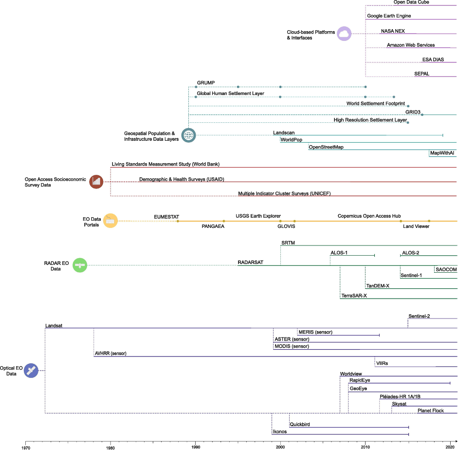
What EO *does* have is a five-decade temporal legacy (most platforms and data products are near continuous), and its broadly open access with low to negligible acquisition costs. EO data is also availabile across multiple spatial resolutions and is often easily comparable and complementary. When we say, ‘five-decade temporal legacy’, this means that there are roughly 50 years of EO data (if we use the Landsat program as an anchor). Not all EO platforms have operated across the whole timeline – Figure 1 below offers an idea of when different platforms were launched and for how long they were, or have been, operational. What’s more, data will be increasingly available and accessible, catalysed by technological innovation and investment in public and private ventures. A lot of this data is open access e.g. EO platforms operated by NASA or the ESA Copernicus programme, which include Landsat, MODIS, AVHRR, VIIRs, and the Sentinels amongst others. Meanwhile, the availability of EO data across multiple spatial resolutions enables disaggregation of data alongside survey and census data for subnational monitoring of socioeconomic conditions.
https://www.sciencedirect.com/science/article/pii/S0303243421001732#b0525
What did we find?
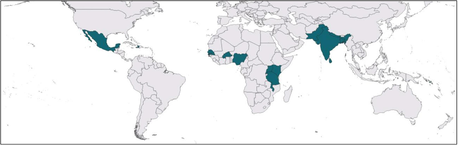
We identified 30 papers that proxied socioeconomic conditions using EO data, and these case studies were concentrated across three main regions: (1) the Indian subcontinent, (2) West Africa, and (3) East Africa (Figure 2.). Most approaches that leverage EO data for proxying socioeconomic conditions operate at a single spatial scale, for a single point in time, and often proxy only a single socioeconomic metric. These are the principal reasons for the lack of confidence in adopting such an approach into the mainstream. Especially since these foster uncertainty for methodological transferability, the ability of EO proxies to proxy socioeconomic metrics at different points in time, and their behaviour across different spatial scales. Meanwhile, the distinction between socioeconomic metrics is key. Poverty and development are contextual. The drivers of poverty experienced by populations in one region will differ from those in another. Each metric tells a different story about the underlying socioeconomic conditions. If, for a given context, we know that an EO approach can proxy an asset index, but do not know how well it proxies income, or multidimensional wellbeing, then there is still uncertainty surrounding the predictive capacity and transferability of the approach. Without effective triangulation there is no certainty that EO can accurately monitor poverty or wellbeing, or transplant to a completely different context. We need to better understand how EO proxies perform when predicting different socioeconomic metrics across different contexts.
https://www.sciencedirect.com/science/article/pii/S0303243421001732#b0525
Landsat and MODIS are the most routinely integrated EO platforms for proxying socioeconomic data. But a huge variety of EO data exists, new platforms are being launched, and recent platforms are reaching a point where they can be used in conjunction with contemporaneous socioeconomic data. For example, the ESA Sentinels, which are primed for this application (e.g. the high spatio-temporal resolution of Sentinel-2). Complementarity among EO platforms (e.g., optical and radar), and in combination with other non-traditional data (e.g., geospatial population layers) is underutilised. There is considerable opportunity here to relate a social-ecological understanding[2] of a particular context (such as agroecological conditions or accessibility of services), and to increase data coverage to reach remote and left behind populations. The mantra of the SDGs is “leave no one behind” and EO is perhaps the best medium through which to reach those populations. But it must be done well. This is where SDG 17 [hyperlink] becomes important, enabling capacity building, technological proliferation and its accessibility through triangular regional and international cooperation.
Creating transferable approaches is thus far unresolved. Transferability could be supported by complementarity among EO platforms, but without contextual and local validation it will fall short. Validation with expert and local knowledge is critical, particularly if working at fine spatial scales. At the end of the day, we are talking about applying EO data to people and there is a moral imperative to remember that. The cycle of proxy development should start the local level through a process of co-production. The way in which EO proxies can be used to proxy poverty will differ across different regions, rural and agro-ecological contexts. We found two research cases that established some level of transferability, but the researchers underscored the need for validation and the development of context-specific approaches. We need to refine understanding of the precise boundaries for methodological transferability. The only way to achieve this is to expand data exploration to identify the type of EO metrics that are related to poverty in different locations.
Temporal monitoring using EO data is not yet operational. Of the 30 papers in our review, a single case[3] tested temporal monitoring, and findings were inconclusive. Noise between years in survey datasets was a key issue. Likewise, a recent World Bank working paper[4] tested the capacity of VIIRs night-time light (NTL) data to predict of GDP using longitudinal Living Standard Measurement Study (LSMS) data. In this instance, time series elasticities were much smaller than cross-sectional elasticities, which means that in a time series analysis you could easily overestimate the importance of NTL as a proxy of GDP. There is, therefore, much work required to build confidence in EO data for monitoring socioeconomic conditions through time. This centres on understanding what you’re measuring and applying the right data to the problem, but also accounting for uncertainty and interrogating findings regardless of predictive capacity or accuracy.
The value of EO data is in its availability across multiple spatial resolutions, which could enable aggregation of proxies alongside household survey data. This could feasibly provide a link between the course scale at which policy is typically enacted (e.g., provincial) and the scale at which policy outcomes are expected (e.g., household). But the research cases across the review reported variable predictive accuracies at different spatial scales (e.g., district level proxies of district level poverty), and, to an extent, this is to be expected. However, there’s an argument to made for instead focusing on how coarser scale EO proxies are related to local scale indices of wellbeing and development.
What needs to be achieved?
a) Resolving technical challenges
Based on our findings, we identified 5 key technical requirements that should govern this research space in the near term.
- Develop EO approaches for monitoring poverty dimensions across multiple spatial scales.
- Standardise approaches for monitoring socioeconomic conditions through time.
- Set boundaries for the transferability of methodologies between different socioecological systems.
- Test the predicative performance of EO proxies for different measures of rural poverty.
- Operationalise the integration of disparate datasets (e.g. optical and radar, EO data and geospatial population layers).
Resolving these technical challenges is the first step to constructing targeted spatio-temporal profiles of poverty and development for a region of interest. The second step entails resolving implementational challenges, discussed below.
b) Resolving practical implementation challenges
Transparency is key. Things need to be interpretable – especially in service of a transparent data system for sustainable development. If EO proxies cannot be interpreted with ease, then accountability and accessibility are lacking. This applies as much to the data derived from EO platforms for input to models as to the models themselves. It’s all fine and well to establish that the median value for red, green and blue bands can predict household wealth. But as I stated before, this is an abstract concept to grasp and difficult to rationalise – especially for policymakers. Obscure methods and models are equally troublesome. For example, artificial intelligence (AI) methods in the analysis phase are certainly useful, particularly for dealing with the size and complexity of EO data. But many of these models (e.g., convolutional neural networks (CNNs)) are essentially black boxes. It’s near impossible to deconstruct the inner workings of the model, for example at what point and why certain predictors are favoured over others.
Despite considerable efforts in international collaboration for training to enhance EO expertise. There is still some way to go before EO capacity is established across institutional levels. But this is essential. The cycle of EO proxy development should start locally, through an iterative process of co-creation and calibration. Spatially disaggregated data are only achievable if there’s horizontal and vertical institutional capacity. At the same time, misuse of EO data will inevitably produce erroneous inferences, which could do far more harm than good. To a non-expert, what may look to be an uninhabited or unused landscape will most certainly be managed, utilised, and governed in ways that cannot be communicated by the electro-magnetic spectrum. This is the rationale for on-the-ground cooperation and validation necessary for directing the use of EO data.
Read the article [hyperlink] for a deep dive on our findings and recommendations!


Recent comments