
Geology Digimap now offers the new GeoCoast dataset, which replaces the Coastal Vulnerability dataset. GeoCoast is available from Geology Download under the Onshore Geology section. It is available in Shapefile format and only as a national datasets (it’s not possible to select a particular area – the whole dataset will be included in the download).
The Coastal erosion data includes:
- Coastal erosion susceptibility (vertical cliff layers, properties).
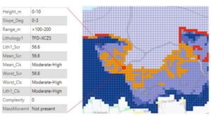
- Cliff profiling (slope angle, distance, cliff height). The gridded properties data + inundation layer contain all the details related to the coast:
- Foreshore (type, properties, spatial area).
- Backshore (type, properties, spatial area).
- Coastal erosion susceptibility (vertical cliff layers, properties).
- Cliff profiling (slope angle, distance, cliff height).
- Inundation under climate change scenarios (future sea level rise forecast for 2050, 2080, 2100).
- Coastal subsidence potential (satellite measurements and lithology type)
- Groundwater flooding & coastal flood (combined hazards indicating exacerbated impact).
This Coastal Vulnerability dataset has been withdrawn and is no longer supported by BGS. However, it remains available through Geology Digimap under the Archived Datasets section. It is provided “as is” and used at your own risk.
GeoCoast replaces Coastal Vulnerability dataset / by ecls is licensed under a Creative Commons Attribution CC BY 3.0