Any views expressed within media held on this service are those of the contributors, should not be taken as approved or endorsed by the University, and do not necessarily reflect the views of the University in respect of any particular issue.
In order to move away from or critically reflect on a western discourse on heritage management and risk assessment you need to listen to a range of voices from different geographies.
The CRITCAL project aimed to better understand the role of heritage within risk assessment through the investigation of three case study sites. We wanted to develop a community of practice across three Low-Middle Income Countries (LMICs) and the UK. The case study sites worked three scales: the small-scale settlement of Elandskloof in South Africa; a city region of Yogyakarta, Indonesia and a national approach across Sri Lanka. Exploring these three scales we were able to capture a narrative-based risk assessment for heritage and found that heritage opens avenues for dialogue on livelihoods, gender, local level capacity and vulnerability.
The video below outlines the importance of understanding culture at a local level.
Three sites, many voices
This module explores three locations. Through videos and text we ask you to consider these studies and reflect on how heritage is understood in different contexts.
In summary we found that heritage can take many forms, for example in this course we have examples of buildings, landscapes, and customs. Furthermore, we found how heritage is important not just because it is vulnerable to climate change but also because it offers capacity. We invite you to explore the posts in this module and learn more about how heritage can be a tool for climate change adaptation and risk reduction.
Methods
The research teams engaged with local communities and experts to address all three original research questions. Their findings are context specific and include alternative and community led visions of cultural heritage and their interconnections with climate change adaptation and sustainable livelihoods. As well as identifying and trialling innovative participatory methods that can be integrated within a wider holistic risk framework that places cultural assets and practice at the heart of resilience building.
At a national scale, Dr Karunarthna carried out multiple interviews and facilitated workshops in rural settlements across Sri Lanka. Furthermore, her work included a review of historical literature exploring the role of women in traditional rural practices. At a city-scale, Dr Retnowati and Ms Anantasari carried out a series of interviews with key stakeholders along the River Code in Yogyakarta region. In South Africa, Prof O’Connell and Ms Niemand led two workshops, a household survey and a series of interviews in Elandskloof, South Africa. In addition, a review of climate data for each site and a systematic synthesis of literature related to heritage, risk and value was undertaken (Crowley et al 2022).
Research findings in brief
The South Africa team, led by Dr Siona O’Connell and Dominque Niemand, identified the influence loss in terms of indigenous knowledge systems and how food heritage may pave the way to intergenerational knowledge exchange. They also explore how violent and forced removals from the land have led to significant vulnerabilities for communities across South Africa. Section 3.2 outlines the case study findings in detail.
In Indonesia the team, Dr Arry Retnowati and Esti Anantasari identified the importance and cultural value of an urban river system and are expanded their work to explore the wider urban setting of Yogyakarta, and it’s bid to become a city-wide UNESCO World Heritage Site. The river’s cultural narrative is critical in understanding local adaptive capacity and vulnerabilities over time, and how cultural heritage is a dynamic force not just something to be preserved. Section 3.4 outlines the case study findings in detail.
In Sri Lanka, Dr Dulma Karunarathna identified the importance of local knowledge for water resource management and the cultural connections for women and their livelihoods. She has also implemented a series of engagements with communities in Sri Lanka through school-based art competitions as well as community storytelling workshops. Section 3.3 outlines the case study findings.
The narratives emerging from the three sites align with the results of the desk-based literature reviews that have identified the serious lack of understanding and integration of intangible cultural heritage, community level engagement, and cultural value in risk assessments for climate change adaptation and disaster management.
This section provides an outline of each case study site explaining the context, and key findings.
Taking into account histories, livelihoods and likely climate change impacts to support forgotten communities in Elandskloof
“Heritage is fluid and complex, it is political in every sense. The work of heritage allows difficult conversations to take place in imaginative ways, allowing for history to be understood as being in the present” -Prof Siona O’Connell, International Co-investigator, University of Pretoria, South Africa.
In South Africa, the scars of inequality and social engineering that characterised the apartheid system persist despite nearly three decades of democracy.
Injustice through forced land ownership changes, brought violent race-based removal of settlements across the Cape Flats. The legacy of historical injustice still affects today as Elandskloof is impoverished in lacking infrastructure, including little formal housing.
The study of vulnerable and forgotten communities – single sites in particular – is therefore utterly crucial. Forgotten communities require context-specific approaches to support them taking into account histories, livelihood portfolios, and likely climate change impact.
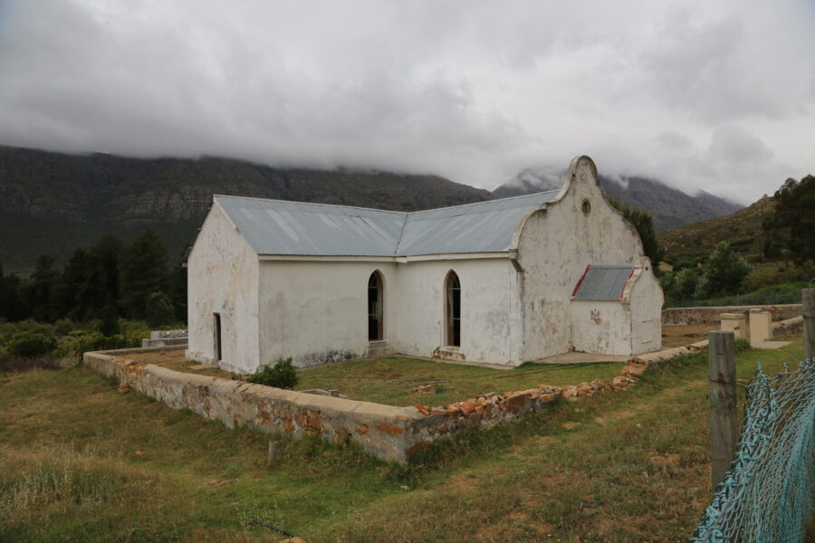
About Elandskloof
Established as a mission station by the Dutch Reformed Church (DRC) in 1861, families from the surrounding area were attracted to settle by the dream of autonomy and dignity – title to a small plot of land, the right to graze your cattle in the surrounding veld, and a community of faith gathered under the wing of the church.
Elandsklowers harvested buchu (Agathosma betulina), kept vegetable gardens, grazed cattle, and worked as seasonal laborers on the surrounding farms. The betrayal, when it came, was dramatic, unexpected, and intimate. In 1961 the DRC sold the land out from underneath them. Residents who were children at the time tell of going to school in the. morning, and returning to find the bulldozers at work on their homes.
Then, like the estimated 3.5 million people in South Africa who suffered forced removal under apartheid, they drifted into the surrounding towns and the dystopian dormitory settlements of the Cape Flats.
In 1996, Elandskloof hit news headlines as the first successful land claim in a newly democratic South Africa. Seventy-six families returned to Elandskloof.
However, over the coming decades, the contradictions in a deeply flawed restitution process came to the fore: land without the capital to develop it, and a group of claimants many decades removed from a meaningful relationship with the business of rural livelihoods, carrying the scars of the struggle for survival under apartheid. In 2005, the Elandskloof Communal Property Association was placed under administration. Today, Elandskloof is an impoverished rural ghetto without infrastructure, and with little formal housing.
Layered onto these traumatic events as an unanticipated and largely indecipherable process has been the reality of anthropogenic climate change. Southern Africa, and the Western Cape, in particular, has been described as a climate change hot-spot, with evidence of warming above the global average.
A rapidly changing climate
The annual average temperature across South Africa in 2019 was around 1.1°C warmer than the average for the period of 1981-2010.
There has also been an increasing trend in extreme temperatures (maximum temperatures) by 0.1-0.3°C a decade across the Western Cape between 1931 and 2020 (South Africa Weather Service, 2020).
There is medium confidence that there has been a long-term decline in soil moisture (increase in aridity) throughout the twenty-first century in west-southern Africa as a result of decreasing precipitation and increased temperatures.
In South Africa the number of droughts have increased by 220% between 1961 and 2016, as a result of anthropogenic forcing (IPCC- AR6).
Food Heritage and Sense of Place
This study foregrounds the importance of culture as central to understanding ways of being.
Cultural scholars and practitioners respond and intervene in creative and productive ways to social contexts and social realities, drawing attention to the lived, material, and embodied realities and crises of the contemporary moment. In the global south and Africa, cultural studies that focus on understanding the human and colonial afterlives provide a framework that allows a critical, immediate and urgent analysis of the world. A focus on food heritage in Elandskloof explores the intimately embodied and everyday aspects of some dauntingly high-level concerns – ideas around culture, identity, history, descendancy, and production in the face of climate change.
We are what we eat goes the platitude. Food plays a central role in all our lives, what we grow, eat and share forms a bond to the land and each other. In rural settlements reliant on agriculture food is a central pillar to the community.
Preparing and sharing food is a ritual through which we build and repair relationships, and nurture those that we care for. Food heritage is interesting because it takes us to such an intimately embodied and everyday aspect of some dauntingly high-level concerns – ideas around culture, identity, history, descendency, and genealogy.
The tangled food heritages of the Cape reference indigenous foodways, the slave diaspora established by the Dutch, missionary proselytization, British colonialism, apartheid segregation and forced removals, and the ambiguities of post-apartheid reconciliation and restitution.
But in Elandskloof food heritage provides a narrative of both hope and loss.
Rebuilding traditional knowledge
The forced removal of the residents during apartheid had a devastating impact on the intergenerational knowledge system in this community. This traumatic dispossession allowed for some practices which took place before the forced removals to disappear. This loss of knowledge is evident from the conversations with the community members. More specifically, Elandsklowers could live sustainably from homegrown crops before the forced removals. This dependency on homegrown crops becomes significant in understanding how other knowledges were created such as recipes. This community currently remains vulnerable as these knowledges and practices seem to disappear with the older generation.
Hybrid knowledge
Can a community recreate lost indigenous knowledge and incorporate new information?
Although Elandskloof is struggling, there is evidence that local and shared knowledge played an important role in adapting to the changing climate but at a very minimal level. Residents recognised that the drought has become an ideal climate in which Buchu and other crops could flourish however, this process is once again hindered by deep divisions within the community. The community has also recognised that they require further knowledge around soil quality and climatic changes to fully benefit from the available land that is still accessible to them.
Questions around heritage surfaces within this community in various ways. The preservation of their tangible heritage has become a point of concern for some residents. At the heart of the community lies the remnants of two-valued buildings, the church, and the community hall or school building. which was part of the original construction when the Elandskloof as a missionary town was established. These buildings are recognised by the community as valuable sites in which learning and worship still take place. These buildings also serve as an important space where residents can find common ground through shared practices such as worship, the hosting of bazaars, and, more importantly, a place for commemorating the past (events are often held by local community leaders in which they try and prompt dialogue on Elandskloof’s history).
What became more prominent, however, is the loss of intangible heritage. Interviews with residents revealed that there is a great loss of intergenerational knowledge due to forced removals. The violent separation of this community has interrupted important practices which depended on generational knowledge passed from father to son or from mother to daughter. One example of these practices includes the importance of food heritage. Residents corresponded that they try and live from what they grow in their gardens, this practice is now only seasonal and stands in stark contrast to before the forced removals (this is confirmed through archive research conducted in the Dutch Reformed Church archives). Most of the recipes that were collected through each visit existed only through memory and were all handed down from mother to daughter. These recipes were designed to be accommodating to the type of crops cultivated in the Elandskloof community.
Many of the residents expressed the need for valuable helpful data on climate and agriculture.
While Elandskloof is still under administration which prohibits the cultivation of the existing orchard, some community members have collectively planned new areas for harvesting on the land for Elandskloof
It is evident from visits that the community would benefit from access to climactic information, including this information with some of the indigenous knowledges would be beneficial and could promote a new sense of cohesion in the community. Currently the question of land is still a contentious point within the community.
The Future
The future of Elandskloof remains uncertain for the residents. While some responded hopeful with renewed efforts around agricultural cultivation, there was a sincere concern toward the future of Elandskloof. Most residents expressed that the future of Elandskloof is reliant on the new generation who, according to older residents, show little interest in the legacy of Elandskloof. Residents in Elandskloof prioritise day-to-day planning rather than long term planning however there is a concern for climactic threats in the future.
Currently the residents have remarked some drastic seasonal changes such as re-occurring veld fires as well as higher snow-fall in winter months.
The residents however have not yet adapted to these changes. In some instances it was remarked that the out of the ordinary dry seasons have had some benefit in the cultivation of Buchu and that this specific indigenous crop thrives in these conditions. Current community driven projects have been focused on the planning of new crop cultivation which includes the planting of Rooibos Tea, watermelon, green beans and protea (also known as “tolbos”). They are still unsure which crops the soil will support. The new crops will have a direct effect on food heritage and offer an opportunity to rebuild lost food knowledges. The intention of the planting of these new crops is aimed at uplifting the current state of Elandskloof in hopes of returning to a new self-sustaining community. Some of the community plans include the use of some of the natural water sources in the area, the main source being a river which currently runs through Elandskloof.
Study Recommendations
Policy makers such as Cape Nature are urged to approach members of this community for more inclusive decision making, specifically on the decisions which apply to the Cederberg Nature Reserve. While Elandskloof has attempted to independently manage some of the available opportunities such as the implementation of new small-scale farms on available plots of land, this process has been hindered by the lack of funds and inter-community disputes on decision making. This community will benefit from any assistance which could be provided on any environmental changes. This will assist with the community’s strategy to currently complete agricultural projects which will have a beneficial impact on Elandskloof not only in returning to self-sustainability but also towards the recovering and creation of indigenous knowledges.
This is one of the ArcGIS story map series from the CRITICAL project. Dr Rowan Jackson set up the story map from the South Africa case study provided by Prof Siona O’Connell and Dominique Wnuczek-Lobaczewski (nee Niemand).
The power of environmental folklore and cultural memory for understanding climate change risk and adaptation
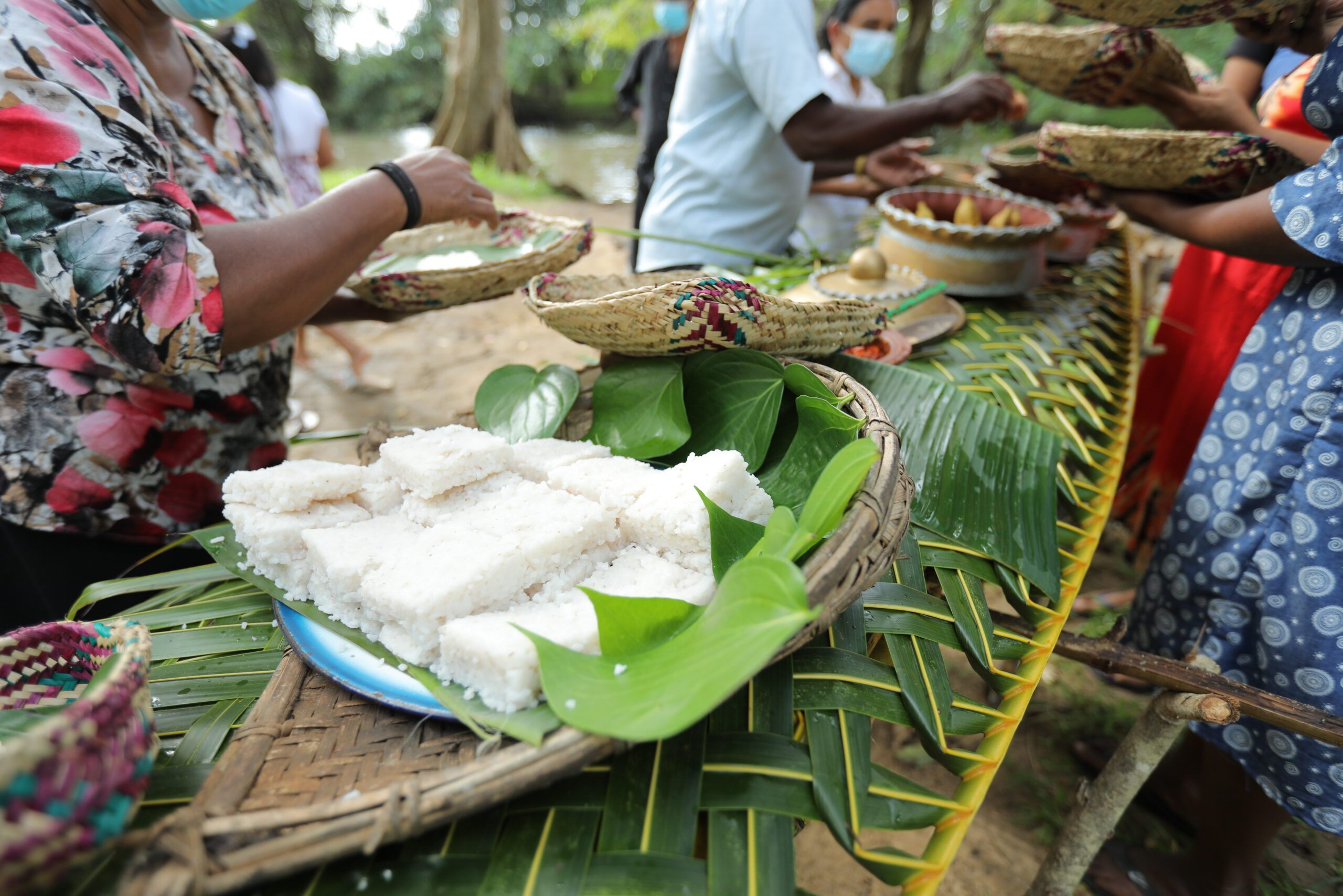
Climate change impact on cultural heritage is one of the obscured areas in Sri Lankan academic scholarship. The prevailing knowledge gap creates an urgent need to reconstruct the indigenous and local climate knowledge systems in Sri Lanka, constructed through a comparative study. The case studies were selected representing ethnic and cultural diversity and cross-regional basis to support this comparative study. This research examines the traditional knowledge systems as a comparative study. Environmental folklore (Intangible Heritage) was collected from small-scale tank cascade village cultures in Sri Lanka.
This conventionally neglected research elaborately magnify the local ecological knowledge, traditional livelihood, contemporary social norms and dynamics, and harmonious connection between culture and nature.
One of the advantages of collecting data from folklore is the opportunity to obtain a detailed version of the profile of women in respective village cultures. Cultural memories of the peoples who are the stakeholders of the Sri Lankan hydraulic civilization offer a detailed narration that is robust enough to fill the lacunae of the social life of women non-elites sidelined in heritage studies.
The research focus
This research mainly examines the role of women in small-scale tank cascade village communities in Sri Lanka as a response to extreme weather events and climate change. Main case studies focused on locations Galtemwewa, North-western province, Moragoda, North-central province, Kalukele, and North-central province. The sub-case studies were conducted to compare the role of women in different ethnic and cultural settings. These locations are Sri Lankan aboriginal community in Dambana, Uva province, Tamil Island community in Delft Island, Northern Province, and coastal fishing community, Ulhitiyawa, North-western Province. Status of women, gender attribution, gender identities, gender roles of these societies were identifies and compared.
Whose heritage?
The earliest writings about Sri Lanka’s history were mainly based on colonial constructions. The main streams of their approaches were colonialism, orientalism, imperialism, and antiquarianism. According to the content of this literature, it is clear that the colonial writers had a preconceived notion about Sri Lankan culture in attempts to understand Sri Lankan life, behavioral patterns, beliefs, rituals and flora, and fauna.
A great number of volumes written the Sri Lankan irrigation systems and detailed recordings of Ceylon ecology and traditional livelihood were used as a tool of colonialism and this understanding helped the colonial administration to plant the Eurocentric values on Sri Lankan earth. This situation created an inferiority complex over traditional livelihood in traditional village cultures, and they started giving up their traditional indigenous values and knowledge systems. However, the knowledge they record can be used as a valuable archival collection.
There is a growing body of literature about tank cascade systems, ecology, biodiversity, agrobiodiversity, biophysical changes, climate change, groundwater chemistry, food and water security, dramatic changes in village cultures and traditions sustainability (Maddumabandara, Marambe, Darmasena, Gunasinghe ) These researches examine the Sri Lankan tanks and agricultural societies through environmental and sociological aspects. They draw our attention to the wider environmental aspect including climate change and environmental relations and issues beyond ancient ingenuity and water management. These research helps to understand the human intervention to the natural environment and their environmental sensitivity and ecological knowledge.
The characteristic elite bias of existing literature and the grandeur of the ancient built environment sidelined the small-scale tank cascades in village contexts.
Traditional livelihood, climate risks, their adaptation strategies were not adequately examined in the Sri Lankan historiography and heritage studies scholarship. The invisibilization of women in these agrarian societies is a knowledge gap of existing literature.
There is a growing body of literature on water security, agriculture, and climate change in Sri Lanka. The gender lenses to climate change and exploring this area through folklore (intangible heritage) and cultural practices and memories were done for the first time of its kind through this study. So, this research undoubtedly fills the gaps in an obscured area in climate science and cultural heritage studies.
Climate Profiles
Temperatures have increased across Sri Lanka, especially since 1980, although these trends are less significant than other parts of the globe. The South Asian monsoon has weakened, causing a decrease in precipitation in the second half of the 20th century, as a result of anthropogenic aerosol forcing (IPCC 6th assessment report). There is variation in rainfall across Sri Lanka, with the southwest experiencing much greater rainfall than the northwest and southwest.
Temperatures across Sri Lanka and the surrounding ocean areas are expected to increase over the next century. Heatwaves and humid heat stress will also be more frequent and intense (IPCC 6th assessment report).
Gender and Environmental Knowledge
Women are often identified as the most vulnerable and victims of extreme weather events. However, this study found challenges faced by women such as gendered division of labour and gender tasks can also enrich and strengthen them with the knowledge of local ecology, traditional weather forecasting, and household management, proactive in water related conditions.
This research offers an alternative profile of energetic and empowered women, providing an alternative picture beyond the domestic sphere demonstrates the strength, capacity, skills, and responsible consumerism and futuristic approaches of women towards the well-being of the family, the society and environment.
Role of women as a heritage bearer and her indigenous climate knowledge can effectively contribute towards climate solutions, climate change adaptation strategies and environmental decision making.
Intergenerational knowledge
Local people explore and examine the natural environment thoroughly and work in alignment with nature. The behaviour of animals, trees, clouds, rainfalls, and many more facets of nature tell them about the natural climate cycle. Moreover, they have ecological memories of the climate hazards.
The villagers have embedded these climate literacies into the indigenous knowledge and passed them down to the next generation to identify the climate change in advance. The folk songs were the best method that worked for this. The children could easily memorize by heart these factors as they were sung by their elders constantly.
For example, tree worship is considered a divine attribution to nature to nurture and save their catchments. Social organization is functioned by customary laws and people understand the importance of the environment and how it badly impact human if they damage to nature. On one hand, they put moral obligations to maintain responsible consumerism and explained the aftermaths of over consumerism. They embedded these ideas in the advisory folksongs and all work songs.
People are told that the trees were the divine home of gods and goddesses. As a result, deforestation was highly discouraged. People started some small shrines next to the trees and hang a branch of the tree whenever they pass the tree. This is a living tradition in the tank cascade villages. These divine attributions are superstitions but they work very well in the village setting in terms of environmental protection and more effective than government laws and rules.
A changing world
Sadly, although this research identified many traditional mechanisms for water and land management that have been passed down through generations, the research also identified some emerging risks faced by the communities. These include:
Unidentified kidney disease – likely due to the chemical fertilizers and pesticides, heavy metals, and chemicals.
Vector-borne disease – Malaria, Dengue
Covid 19 has impact the elderly community and therefore there is a loss of traditional skills and knowledge at a rapid rate.
All these three above health issues caused the death of the elderly community and farmers who were recognized as heritage custodians.
Younger generations tend to seek new occupations and give up their traditional agriculture and craft activities.
Industrial agriculture and traditional paddy cultivation tools are replaced with modern machines. So, work songs are not sung anymore in many villages, and womens’ labour such as reaping, threshing, gathering, and winnowing is done by machines. Community-based agriculture is slowly disappearing. The machines require fuel and cause carbon emissions can be recognized as environmental issues.
There is a vacuum in the traditional knowledge and interpreting the knowledge
This is one of the ArcGIS story map series from the CRITICAL project. Dr Kate Crowley set up the story map from the Sri Lanka case study provided by Dr Dulma Karunarathna.
The changing nature of heritage landscapes and disaster management in Yogyakarta City in Central Java
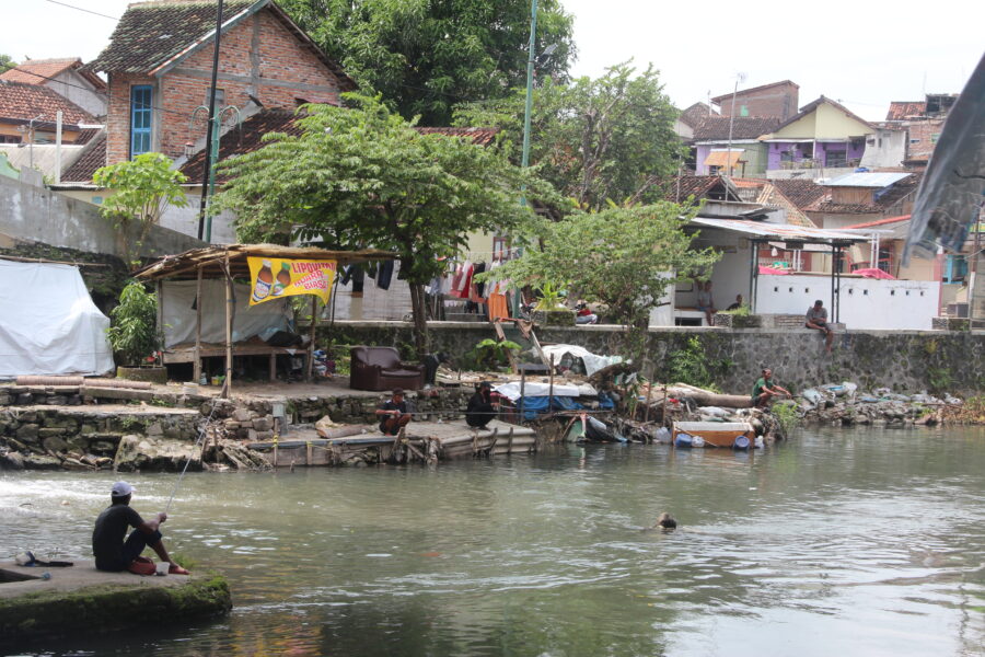
The study sought to understand the correlation between climate-related hazards and the cultural heritage which connects people or the community to their environment. Early on it was apparent that the river systems that cut through the city of Yogyakarta from their source on Mt Merapi to their mouth at the south sea are critical heritage assets.
The River Code became a focal point for the study. Interviews, desk study, and field observation were conducted to better understand and identify the heritage of Yogyakarta city and the natural landscape of the province stretching from the Merapi volcanic area southward along the main southern rivers to the sea – a traditional Javanese cosmological axis through the city.
This study coincided with an application to UNESCO to create a city wide World Heritage Site in Yogyakarta. But the research team were concerned that the proposal put to UNESCO in early 2021 includes no climatic factors discussed, and the designated area of the cosmological axis proposed to UNESCO has not included the river or water issues in the discussion and the proposal. The designated area mainly focuses on the historical building with economical values at present.
This research thus explored on how to build a resilient community that relates to its heritage value, also on how far policy making (regulations) consider local level community heritage values.
A cultural centre
The Special Region of Yogyakarta is located in the southern part of the island of Java, directly adjacent to the Indian Ocean. Yogyakarta is one of the well-known destination cities for tourism and education in Indonesia. Yogyakarta is a city and also a provincial area. As a province, it is known as Yogyakarta’s “special” province or Daerah Istimewa Yogyakarta due to its significance in Javanese history and national identity. The morphological layout of Yogyakarta has a cultural concept called Hamemayu (Memayu) Hayuning Bawono, which means to manage the earth (environment) wisely to maintain sustainability.
Given its geographic location the city is prone to earthquakes, volcanic eruptions, landslides, floods and droughts. Hazards and their risks have been historically taken into account and shared by the people of Yogyakarta in their daily life based on experiences, stories, and written knowledge. The knowledge has evolved and developed into the concept of the symbiotic character of humans responding and reacting to nature.
Catastrophic changes in the natural physical environment resulting from climate change, such as flooding, rising sea level, and its associated coastal impacts, and landslides can have great impacts on cultural heritage, both tangible and intangible. Yogyakarta, as one province in Indonesia, faces several hazards due to its physical features and anthropogenic factors. Changing climate trends and weather hazards are gradually impacting rural areas on the outskirts of Yogyakarta and within the city of Yogyakarta. Agriculture and ecosystem-based tourism sectors annually experience hydrometeorological hazards with potential risk and disaster. In the urban area, the climatic factors disrupt daily urban activities, particularly for the tourism sector dependent on visitors to monuments, landmarks, and the cultural landscape of the City of Yogyakarta.
Vulnerability for cultural heritage needs to take into account the aspects of the heritage itself, both intangible and tangible.
Climate Profiles
A long term warming trend across Asia has accelerated since 1970 and drought and floods are of major concern across every region in Asia (IPCC- AR6). Heat waves are becoming more frequent, longer- lasting and more intense across most of Southeast Asia (Li, 2020).
Average monthly rainfall in Java fluctuates similar to the Australian monsoon pattern throughout the year, with highest rainfall occurring in December and January (350 mm/month) and the lowest in August (80 mm/month). Precipitation related hazards, such as drought and floods are of major concern across every region in Asia (IPCC AR6). Average monthly rainfall in Java fluctuates similar to the Australian monsoon pattern throughout the year, with highest rainfall occurring in December and January (350 mm/month), and the lowest in August (80 mm/month) and low between June and September. Precipitation is higher in the southwest and central Java. Annual rainfall in Yogyakarta is relatively high compared to the rest of Java, and appears to be increasing in more recent years (Faradiba., 2021).
Changes in precipitation are often a result of weather patterns such as the El-Niño and La-Niña (Berliana et al., 2021). The arrival of an El-Niño such as in 1997 and 2015, resulted in a prolonged dry season, whilst La-Niña, such as in 1999/2010 and 2016, causes an increase in rainfall and sea level surges which caused flooding across Indonesia, especially along the coast (Handoko et al., 2021). Drought and flooding affected a reduction in crop production, as well as the potential to significantly alter groundwater and drinking supplies (Hohl et al., 2020 and Susanti et al., 2021). Future projections note that although precipitation may decrease leading to drought and water shortage, monsoonal rains and extreme rainfall associated with tropical cyclones may increase. These extreme rainfall events could lead to flooding and remobilization of volcanic material (lahars) within the Yogyakarta river systems.
The coastal areas of Yogyakarta are at risk of sea-level rise such as the Galur district being abraded by more than 350 square metres, whilst Srandakan grew by 270 square metres between 2000 and 2018 (Susanti et al., 2021).
Future sea level change is likely to continue and exceed current rates in the oceans around Asia ranging from 0.3-0.5m under SSP1-RCP2.6, to 0.7-0.8m under SSp5-RCP8.5 for 2081 to 2100 relative to 1995-2014 (IPCC AR6). Sea temperatures and coastal floods are also estimated to increase (IPCC AR6).
The heritage landscape of Yogyakarta
The city is connected to the volcano Mt Merapi, in the north and the Indian Ocean in the south via a series of river systems. This is know as the cosmological axis of Yogyakarta and it links a series of tangible and intangible heritage assets including the volcano together with the Sultan’s Palace, and the Parangtritis coastal area. Along this route are many heritage sites of signifcant national value including Prambanan Temple (a World Heritage Site), Malioboro Street, Tuga Monument, and Kotagede.
The Indonesian Charter for Heritage Conservation (2003) stated that 1) The heritage of Indonesia is the legacy of nature, culture, and saujana (landscape and livescape); 2) Cultural heritage includes both tangible and intangible legacies; 3) Heritage, bequeathed from the generations that precede us, is a vital foundation and initial capital for the development of the Indonesian nation in the future, and for these reasons, must be conserved and passed along to the next generation in good condition, without loss of value, and if possible with an enhanced value, to form heritage for the future.
There is a strong interconnectivity between the community and the cosmological axis. The rivers shape the whole landscape as part of the axis that connects Merapi volcano, the Sultanate Palace, and the Parangtiris coast. These locations symbolize human and the spiritual aspect (God) connections. This philosophical heritage is repeatedly introduced to visitors spending their time in Yogyakarta.
There are gaps in understanding the influence of climate change and current political decisions on heritage management.
In this area the value of the River Code varies considerably from national to local government and their drive to propose the cosmological axis as one World Heritage Site, and the local people who live and interact with the river and it’s hazards. This research therefore aimed to explore the river as heritage, and understand the local and regional narratives associated with heritage and natural hazards.
The river as a tool for connecting people and their heritage
With a backdrop of dynamic environmental conditions in Yogyakarta, there are historical landmarks that were placed alongside several geographical icons such as mountains, rivers, and oceans. Those icons do not stand alone, but they are parts of a constellation of cultural sites and the cultural values have been continued to bind, live, and interpreted in various ways by the people of Yogyakarta.
For example, indigenous knowledge and cultural memories relating to Merapi volcano, such as beliefs, livelihoods, and the kinship of the people who live around volcano will always be there, even if one day the tangible heritage disappears. This indicates that Yogyakarta has cultural value through the intangible heritage which is constructed around the landscape and provides guidance to the way people protect and interact with their environment.
The River Code’s inhabitants, for example, held regular and annual events or ceremonies to build public awareness in the conservation of the Code River existence as part of valuing cultural ecosystem services. Merti Code is one of the traditional knowledge areas regarded as ecosystem service based on human and environmental connections. Merti is a Javanese word that means “taking care of something”. The Winongo river inhabitants held the merti river, similar to the Code River community. Such behaviour, knowledge, and daily practices have shaped the cultural landscape of Yogyakarta.
Traditional warning systems are being lost. For example, environmental folklore relating to lahar warnings are now not being passed through generations because of the changing communities alongside the river.
Dynamic change
Cultural heritage in this region is always changing, it reacts to changes in the landscape through floods, volcanic eruptions and earthquakes and to globalisation. Since, the 1970s the river banks have become slum areas, with new immigrants seeking cheap lands to populate. The Code River banks have become densely populated and this has caused a sever decline in water quality. What was once a source of drinking water and regarded as healing waters are now polluted. The city itself has also taken advantage of the river systems, with an increase in tourist facilities such as hotels, hostels, restaurants, souvenir shops, markets, offices.
In some areas there is hope, with local residents forming their own community groups to protect the river, share their knowledge but also ensure local people can take advantage of relevant tourism.
Here heritage provides a significant source of livelihood in the city and yet some ancient heritage is threaten by pollution, loss of traditional knowledge that focuses on the protection of the environment and how to live alongside nature. The UNESCO World Heritage Site status for the city provides economic benefits but questions remain about how will this benefit those living in the city? Are we seeing yet another shift away from local value of heritage to something ‘global’ and sanitised? And how can we protect these sites if natural hazards are not considered within the planning of cultural urban spaces?
Final recommendations
Climatic factors should be included into heritage management and development planning.
Re-introduce climatic factors to all stakeholders and the communities alongside the cosmological or philosophical axis of Yogyakarta to create a mitigation and adaptation awareness culture.
Strengthen the role of the community and cultural value with environmental preservation, and as the main driver in the management and development of the Code River.
Implement Nature Base Solutions t to protect the philosophical values of the Yogyakarta axis
This is one of the ArcGIS story map series from the CRITICAL project. Dr Kate Crowley set up the story map from the Indonesia case study provided by Dr Arry Retnowati, Esti Anantasari and Indriya Parahita.