Any views expressed within media held on this service are those of the contributors, should not be taken as approved or endorsed by the University, and do not necessarily reflect the views of the University in respect of any particular issue.
CRITICAL: Cultural Heritage Risk and Impact Tools for Integrated and Collaborative Learning
Watch this short video to learn more about the CRITICAL project.
Who is part of the team?
Our team includes researchers in Sri Lanka, South Africa, Scotland and Indonesia!
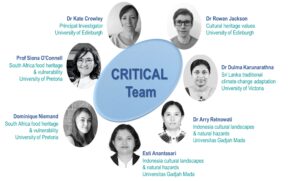
The team at the University of Edinburgh, UK, includes Dr Kate Donovan, Dr Rowan Jackson and Dr Younghwa Cha.
In South Africa, research examining food heritage and vulnerability is being led by Prof Siona O’Connell and Ms Dominque Wnuczek-Lobaczewski from the University of Pretoria.
In Sri Lanka, Dr Dulma Karunarathna is working on traditional climate change adaptation.
In Indonesia Dr Arry Retnowati and Ms Esti Anantasari from the Universitas Gadja Mada are examining cultural landscapes and natural hazards.
We represent communities from all over the world and hope to share our understanding of the relationship between cultural heritage, disasters and climate change.
Why is it important to understand risk?
There is an urgent need to support the world’s most vulnerable populations to adapt and thrive to rapid environmental change. Understanding climate change and disaster risk is the fundamental first step towards building resilience. This involves understanding both the hazard but also the people and assets exposed to that hazard.
Why should we care about cultural heritage and risk?
Cultural Heritage shapes our identity, delivers capacities and exposes vulnerabilities yet cultural value and vulnerability are missing from conventional risk assessments that support sustainable development and growth. Fundamentally, this means that the things that motivate people, build their resilience and in some cases make them susceptible to hazards is missing from decisions about adaptation and emergency management.
Understanding the vulnerability and value of cultural heritage (e.g. beliefs, buildings, and traditions) is vital to building resilience globally.
What are we doing?
We are working in partnership across Indonesia, South Africa, and Sri Lanka to combine heritage management, cultural geography and climate risk research to form a community of practice focused on Low and Middle Income Countries (LMICs). Our diverse team aim to identify and develop interdisciplinary methods to capture the ‘invisible’ vulnerability and value of heritage and incorporate this within risk assessment.
Crucially, this project will collate and share diverse experiences, knowledge and skills to build a portfolio of pilot case studies from the three LMICs on cultural value for climate and disaster risk assessment and management.
The project will finish in early summer 2022 but we will update the course as new learning emerges.
This course was developed by the CRITICAL research team.
Full team and affiliations:
Kate Crowley1; Rowan Jackson1; Siona O’Connell2; Dulma Karunarthna3; Esti Anantasari4; Arry Retnowati4; Dominique Niemand2 , Younghwa Cha1, Ashrika Sharma1, and Aythya Young1.
School of GeoSciences, University of Edinburgh, Edinburgh, UK
Faculty of Humanities, University of Pretoria, Pretoria, South Africa
Centre for Asia Pacific Initiatives, University of Victoria, Victoria, BC, Canada
Centre of Excellence in Technological Innovation for Disaster Mitigation (GAMA-InaTEK), Universitas Gadjah Mada, Yogyakarta, Indonesia
CRITICAL aims to work in partnership this project will combine heritage management, cultural geography and climate risk research to form a community of practice including researchers from South Africa, Sri Lanka and Indonesia to:
1) identify the key parameters for cultural heritage impact assessment;
2) deliver risk scenarios for decision-making, and
3) share resulting tools and learning through a capacity building and research-to-policy strategy.
The changing nature of heritage landscapes and disaster management in Yogyakarta City in Central Java
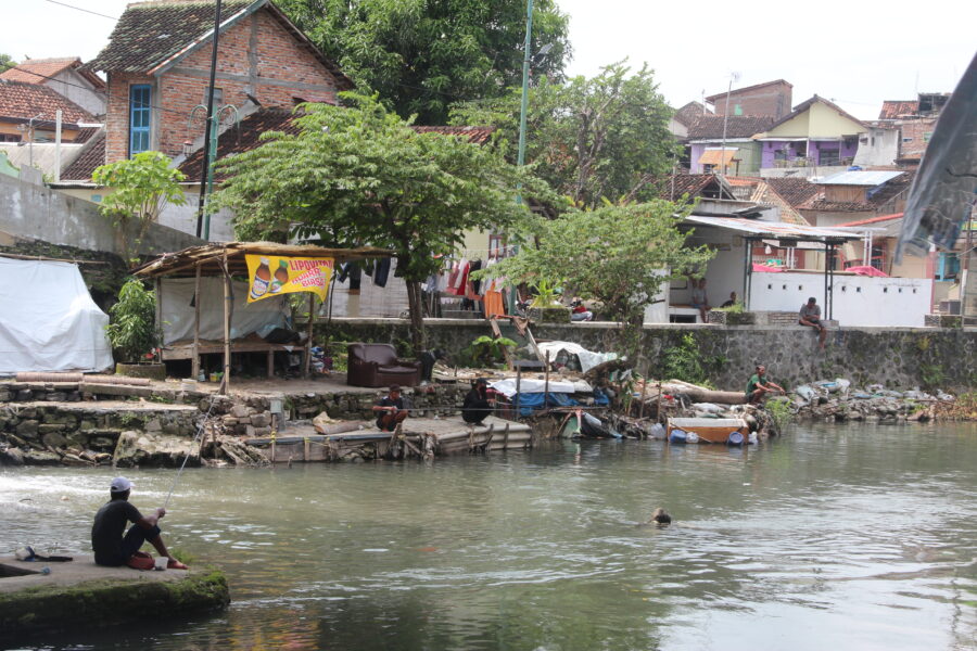
The study sought to understand the correlation between climate-related hazards and the cultural heritage which connects people or the community to their environment. Early on it was apparent that the river systems that cut through the city of Yogyakarta from their source on Mt Merapi to their mouth at the south sea are critical heritage assets.
The River Code became a focal point for the study. Interviews, desk study, and field observation were conducted to better understand and identify the heritage of Yogyakarta city and the natural landscape of the province stretching from the Merapi volcanic area southward along the main southern rivers to the sea – a traditional Javanese cosmological axis through the city.
This study coincided with an application to UNESCO to create a city wide World Heritage Site in Yogyakarta. But the research team were concerned that the proposal put to UNESCO in early 2021 includes no climatic factors discussed, and the designated area of the cosmological axis proposed to UNESCO has not included the river or water issues in the discussion and the proposal. The designated area mainly focuses on the historical building with economical values at present.
This research thus explored on how to build a resilient community that relates to its heritage value, also on how far policy making (regulations) consider local level community heritage values.
A cultural centre
The Special Region of Yogyakarta is located in the southern part of the island of Java, directly adjacent to the Indian Ocean. Yogyakarta is one of the well-known destination cities for tourism and education in Indonesia. Yogyakarta is a city and also a provincial area. As a province, it is known as Yogyakarta’s “special” province or Daerah Istimewa Yogyakarta due to its significance in Javanese history and national identity. The morphological layout of Yogyakarta has a cultural concept called Hamemayu (Memayu) Hayuning Bawono, which means to manage the earth (environment) wisely to maintain sustainability.
Given its geographic location the city is prone to earthquakes, volcanic eruptions, landslides, floods and droughts. Hazards and their risks have been historically taken into account and shared by the people of Yogyakarta in their daily life based on experiences, stories, and written knowledge. The knowledge has evolved and developed into the concept of the symbiotic character of humans responding and reacting to nature.
Catastrophic changes in the natural physical environment resulting from climate change, such as flooding, rising sea level, and its associated coastal impacts, and landslides can have great impacts on cultural heritage, both tangible and intangible. Yogyakarta, as one province in Indonesia, faces several hazards due to its physical features and anthropogenic factors. Changing climate trends and weather hazards are gradually impacting rural areas on the outskirts of Yogyakarta and within the city of Yogyakarta. Agriculture and ecosystem-based tourism sectors annually experience hydrometeorological hazards with potential risk and disaster. In the urban area, the climatic factors disrupt daily urban activities, particularly for the tourism sector dependent on visitors to monuments, landmarks, and the cultural landscape of the City of Yogyakarta.
Vulnerability for cultural heritage needs to take into account the aspects of the heritage itself, both intangible and tangible.
Climate Profiles
A long term warming trend across Asia has accelerated since 1970 and drought and floods are of major concern across every region in Asia (IPCC- AR6). Heat waves are becoming more frequent, longer- lasting and more intense across most of Southeast Asia (Li, 2020).
Average monthly rainfall in Java fluctuates similar to the Australian monsoon pattern throughout the year, with highest rainfall occurring in December and January (350 mm/month) and the lowest in August (80 mm/month). Precipitation related hazards, such as drought and floods are of major concern across every region in Asia (IPCC AR6). Average monthly rainfall in Java fluctuates similar to the Australian monsoon pattern throughout the year, with highest rainfall occurring in December and January (350 mm/month), and the lowest in August (80 mm/month) and low between June and September. Precipitation is higher in the southwest and central Java. Annual rainfall in Yogyakarta is relatively high compared to the rest of Java, and appears to be increasing in more recent years (Faradiba., 2021).
Changes in precipitation are often a result of weather patterns such as the El-Niño and La-Niña (Berliana et al., 2021). The arrival of an El-Niño such as in 1997 and 2015, resulted in a prolonged dry season, whilst La-Niña, such as in 1999/2010 and 2016, causes an increase in rainfall and sea level surges which caused flooding across Indonesia, especially along the coast (Handoko et al., 2021). Drought and flooding affected a reduction in crop production, as well as the potential to significantly alter groundwater and drinking supplies (Hohl et al., 2020 and Susanti et al., 2021). Future projections note that although precipitation may decrease leading to drought and water shortage, monsoonal rains and extreme rainfall associated with tropical cyclones may increase. These extreme rainfall events could lead to flooding and remobilization of volcanic material (lahars) within the Yogyakarta river systems.
The coastal areas of Yogyakarta are at risk of sea-level rise such as the Galur district being abraded by more than 350 square metres, whilst Srandakan grew by 270 square metres between 2000 and 2018 (Susanti et al., 2021).
Future sea level change is likely to continue and exceed current rates in the oceans around Asia ranging from 0.3-0.5m under SSP1-RCP2.6, to 0.7-0.8m under SSp5-RCP8.5 for 2081 to 2100 relative to 1995-2014 (IPCC AR6). Sea temperatures and coastal floods are also estimated to increase (IPCC AR6).
The heritage landscape of Yogyakarta
The city is connected to the volcano Mt Merapi, in the north and the Indian Ocean in the south via a series of river systems. This is know as the cosmological axis of Yogyakarta and it links a series of tangible and intangible heritage assets including the volcano together with the Sultan’s Palace, and the Parangtritis coastal area. Along this route are many heritage sites of signifcant national value including Prambanan Temple (a World Heritage Site), Malioboro Street, Tuga Monument, and Kotagede.
The Indonesian Charter for Heritage Conservation (2003) stated that 1) The heritage of Indonesia is the legacy of nature, culture, and saujana (landscape and livescape); 2) Cultural heritage includes both tangible and intangible legacies; 3) Heritage, bequeathed from the generations that precede us, is a vital foundation and initial capital for the development of the Indonesian nation in the future, and for these reasons, must be conserved and passed along to the next generation in good condition, without loss of value, and if possible with an enhanced value, to form heritage for the future.
There is a strong interconnectivity between the community and the cosmological axis. The rivers shape the whole landscape as part of the axis that connects Merapi volcano, the Sultanate Palace, and the Parangtiris coast. These locations symbolize human and the spiritual aspect (God) connections. This philosophical heritage is repeatedly introduced to visitors spending their time in Yogyakarta.
There are gaps in understanding the influence of climate change and current political decisions on heritage management.
In this area the value of the River Code varies considerably from national to local government and their drive to propose the cosmological axis as one World Heritage Site, and the local people who live and interact with the river and it’s hazards. This research therefore aimed to explore the river as heritage, and understand the local and regional narratives associated with heritage and natural hazards.
The river as a tool for connecting people and their heritage
With a backdrop of dynamic environmental conditions in Yogyakarta, there are historical landmarks that were placed alongside several geographical icons such as mountains, rivers, and oceans. Those icons do not stand alone, but they are parts of a constellation of cultural sites and the cultural values have been continued to bind, live, and interpreted in various ways by the people of Yogyakarta.
For example, indigenous knowledge and cultural memories relating to Merapi volcano, such as beliefs, livelihoods, and the kinship of the people who live around volcano will always be there, even if one day the tangible heritage disappears. This indicates that Yogyakarta has cultural value through the intangible heritage which is constructed around the landscape and provides guidance to the way people protect and interact with their environment.
The River Code’s inhabitants, for example, held regular and annual events or ceremonies to build public awareness in the conservation of the Code River existence as part of valuing cultural ecosystem services. Merti Code is one of the traditional knowledge areas regarded as ecosystem service based on human and environmental connections. Merti is a Javanese word that means “taking care of something”. The Winongo river inhabitants held the merti river, similar to the Code River community. Such behaviour, knowledge, and daily practices have shaped the cultural landscape of Yogyakarta.
Traditional warning systems are being lost. For example, environmental folklore relating to lahar warnings are now not being passed through generations because of the changing communities alongside the river.
Dynamic change
Cultural heritage in this region is always changing, it reacts to changes in the landscape through floods, volcanic eruptions and earthquakes and to globalisation. Since, the 1970s the river banks have become slum areas, with new immigrants seeking cheap lands to populate. The Code River banks have become densely populated and this has caused a sever decline in water quality. What was once a source of drinking water and regarded as healing waters are now polluted. The city itself has also taken advantage of the river systems, with an increase in tourist facilities such as hotels, hostels, restaurants, souvenir shops, markets, offices.
In some areas there is hope, with local residents forming their own community groups to protect the river, share their knowledge but also ensure local people can take advantage of relevant tourism.
Here heritage provides a significant source of livelihood in the city and yet some ancient heritage is threaten by pollution, loss of traditional knowledge that focuses on the protection of the environment and how to live alongside nature. The UNESCO World Heritage Site status for the city provides economic benefits but questions remain about how will this benefit those living in the city? Are we seeing yet another shift away from local value of heritage to something ‘global’ and sanitised? And how can we protect these sites if natural hazards are not considered within the planning of cultural urban spaces?
Final recommendations
Climatic factors should be included into heritage management and development planning.
Re-introduce climatic factors to all stakeholders and the communities alongside the cosmological or philosophical axis of Yogyakarta to create a mitigation and adaptation awareness culture.
Strengthen the role of the community and cultural value with environmental preservation, and as the main driver in the management and development of the Code River.
Implement Nature Base Solutions t to protect the philosophical values of the Yogyakarta axis
This is one of the ArcGIS story map series from the CRITICAL project. Dr Kate Crowley set up the story map from the Indonesia case study provided by Dr Arry Retnowati, Esti Anantasari and Indriya Parahita.