CRIME REDUCTION AND NEIGBORHOOD RESILIENCE THROUGH REGENERATION
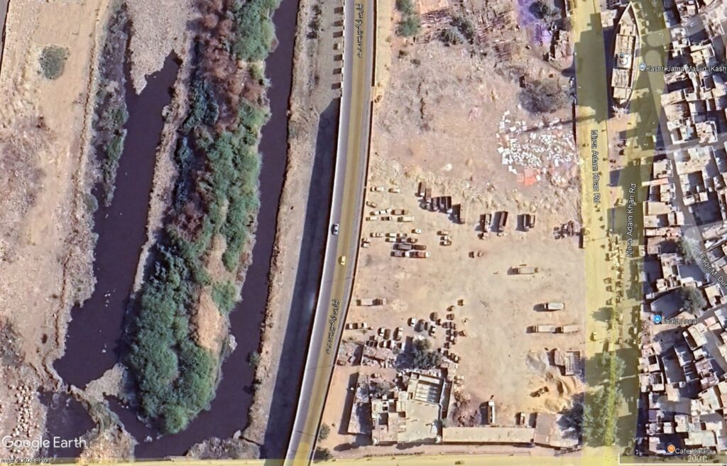
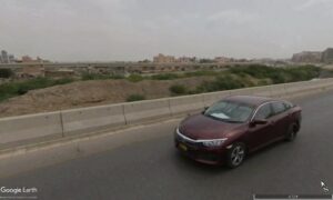
If you ask anyone in Karachi which neighborhood to really avoid, which spot in town is the number one for getting mugged or worse, odds are you’ll get Lyari – the neighborhood, which partially pictured above. And it’s a pity, really. The district of Lyari is a long stretch of land along the long stretch of Lyari river. And what’s done with the land is trash dumping, low quality living, poor (barely present) manmade infrastructure that partially obstructs blue infrastructure, and this cluster of trees on the other end of the river that huddle together mysteriously and don’t really spell out ‘great place to be spotted in case anything happens to you’ to innocent passersby (read: potential stabbing victims).
According to the principles learnt in Regenerating Places, I’ll be taking this bit of land and trying to see how it could be sustainably improved in order to up the green and blue infrastructures and connections, as well as increase economic resilience of the neighborhood, and, of course safety.
Here’s how I’m looking at it:
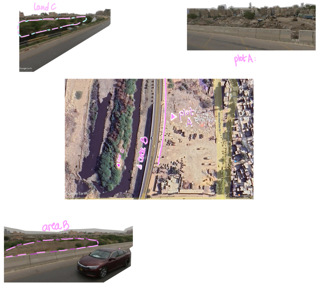
I’ll be going through befores-and-afters of each place.
Plot A
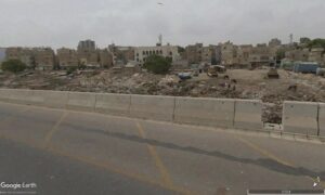
The current way Plot A is, there’s rubble, mounds of dirt and trash, people living in with poor electricity whenever load shedding lets up, and, in general, an area pretty rife for opportunity for gang shootouts (though the frequency of this has gone down drastically over the past decade), mafia activity, and more. People who work here tend to have to travel to another district for their jobs, and there’s not a lot of cultural, and/or child-friendly use of the space. Trees are not at all sparse in Karachi, but in Lyari they’re not planted sufficiently to create a well-connected green infrastructure both within and around the district. The summer sun is never forgiving in this area, and this expanse is treated as good for nothing – even though there is great potential for multiple safe, family activities and economic resilience, if only the area was greened.
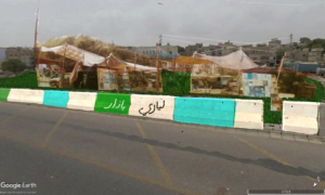
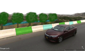
Therefore, in the ‘after’ photo, I’ve applied xeriscaped grass to the area, able to withstand the heat and self-maintain via groundwater available naturally in the dirt and through rain. On the grass, a park could be made, but what I’ve brough to the forefront, to catch the eye of people driving by on the toll road, is a typical Pakistani bazaar with ordinary stalls and local goods and produce. The stalls could be assembled out of the garbage in the rubble, or purchased from manufacturers. The main goal is to have economic activity generated in this area that takes over most of the neighborhood, ensuring people from within and without the neighborhood can take part in a communal activity. With this space used and lots of traffic coming in and going out throughout the day, and hopefully well into the night, petty crimes and even organized crime could be reduced to an extent, with the phenomena of ‘eyes on the street’ allowing more surveillance of people one another.
This would also be in response to general opinion that, although not necessarily taken through a survey the Place Standard Tool, Lyari becomes especially dangerous after dark, with people encouraged not to step foot into the area; that there are no streetlights; and that there are no CCTV cameras. By the establishment of a daily and nightly public bazaar, it makes sense to install CCTVs, and to install lighting over every stall, so as to ensure buyers can view the products well, and sellers can keep track of what’s happening in their surroundings, and to their stalls. If a park is made adjacent to the bazaar, there would be greater attraction for families, which could in turn attract food vendors to the outskirts of the park, as well as toy vendors, and so on – as well as further light and CCTV installation, and perhaps even hired public security for the park. More and more traffic, able to keep down crime rate essentially by forcing out that type of activity by communal, alternative usage of the space.
By painting over the boundaries of the bazaar that incidentally faces the toll road, a brighter, bolder, and more welcoming neighborhood identity may be encouraged to grow within Lyari.
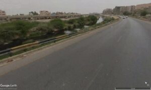
Area B
The other end of the toll road faces the river, but the river can only be seen the closer the road dips to ground level. Higher up, not much can be seen apart from dirt, dirt, more dirt, and the occasional wispy-leafed hedge. Then the distant trees across the river. It’s dull, and there’s no need for it to be that way. The blue infrastructure of the area is significantly under-utilized. Compared to Edinburgh, where online users logged their passion for biking past the river and trees and enjoying the view, feeling it refreshed them and helped their morale, here the river is almost entirely cut off from the portion of Lyari I’m looking at. Unless you’re in a particularly Elizabeth-Bennetian mood to go for a walk, it isn’t easy to reach. Not everyone is always in that mood; not everyone can walk. It’s inaccessible.
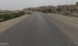
In the after picture, what I’ve decided is that the mounds are too high even for flood-barriers. The dirt can be landscaped in ridges for that purpose and curved downwards to allow for at least glimpses of the river as one drives along the road, and with xeriscaping of trees, grass, and hedges along the slope of that embankment, a better, healthier green infrastructure. Tree wells can also be lined with light, so as to provide better visual access along the embankment at night, in case a civilian needs help in some way and is stuck in that location for some reason.
The barrier to the embankment can also be painted over to match the other end of the road.
Land C
Here, I wasn’t sure how to landscape this plot of trees on the other side of the river – I honestly don’t have the heart to cut anything down. But if it’s possible to create pathways, lighting and perhaps even set up a security station with a little store for basics to be sold – as well as an official access from the land to this delta ground – officializing and overlooking access to the area may make it safer in case of crime and accidents.
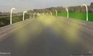
Finally, the road itself – the before and after I believe is pretty self-explanatory and also responds to an issue raised earlier. No lighting; here, streetlights with attached CCTV cameras will help regulate traffic at night, and also add more ‘eyes on the street’ and visibility and surveillance.
Still, even if the Lyari neighborhood was given these material opportunities to improve quality of life, crime is inevitable. People might take down the CCTVs, attempt to plunder the bazar regardless, and lay waste to the park. What Lyari needs more than anything else, is prioritization by the government. Policywork that allows neighborhoods a chance to get on their own feet, and security and funds that allow them to improve on their own terms regardless of what organized crime setbacks may have in store for them.
Of course, this does not absolve the government of responsibility for dealing with that organized crime, but in the likely cases that the government cannot cover all bases efficiently enough at an adequate ground-level, locals should be surrounded by a legal and materially serviced infrastructure that functions adequately and helps them whenever they need.


Your vision for regenerating Lyari is both inspiring and practical. You’ve thoughtfully applied the principles from Regenerating Places to transform a neglected area into a safer, more vibrant community. The idea of combining green spaces, a public bazaar, and improved infrastructure, like lighting and CCTV, shows a comprehensive approach to tackling crime and enhancing neighbourhood resilience. It’s clear that you’re thinking long-term about both physical improvements and community empowerment, which could bring lasting positive change.