[SEM2] Site Week 5.5 02/23/2022
Engraving and cutting designs are ready for both the board and zoomed map created with Illustrator. The more zoomed map will be engraved onto a big wood plate, nailed onto the gallery wall and positioned above the monitors so they audiences can see physically see all these railway station sites on the map in detail. The broader version of the map will be spray-painted on the surface (3 sides with 1 side against the wall) of the pedestal (where the monitors will be placed on) using laser cut stencils.
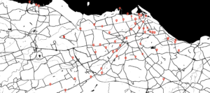
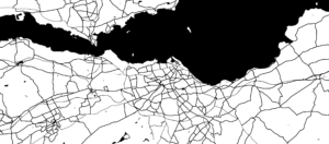
For the site proposal, I am creating mockups with my videos on train station/bus stop billboards, bus/train station monitors, and other locations where they have a built-in spot to show a moving image work (since I recently learn that there is not TV monitors on trains so I will only be using those monitors on buses to play my video work). The guidebook (which will be printed out on paper) consists of 2 parts. The first part has the 4 map: a general map marked with all demolished sites, two maps with existing rail trucks highlighted, and the last map showing all the traffics including bus routes and all the other roads. Then the second part has all the coordinates and information for all 55 demolished railway stations.


Recent comments