[SEM2] Site Week 5.5 02/22/2022
Update on the embassy project:
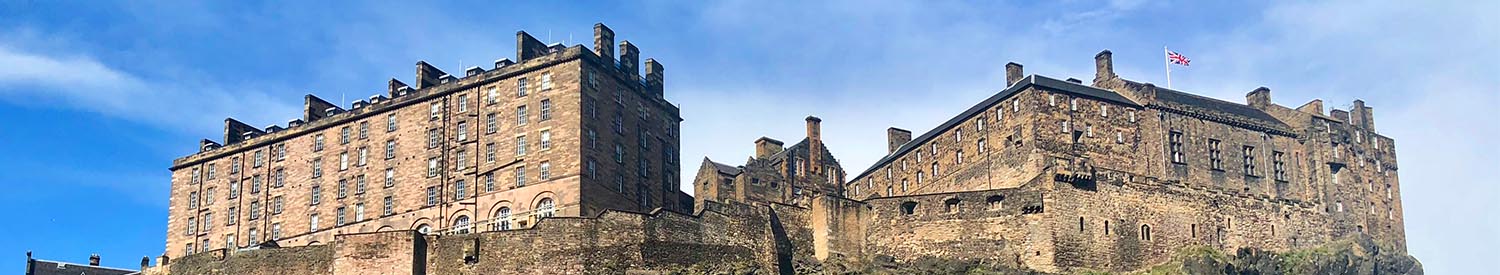
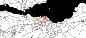
After the tutorial with Aurelien, I decided to narrow down my focuses from the broad rage of non-places (negative places) and positive places to railway stations, where I’m tracking down the disused railway stations in Edinburgh to specific coordinates as accurate as possible (either they are demolished, forgotten, or transformed into other completely different sites) and then lay these coordinates out onto a map. Then I will import the map in illustrator and use laser cutter to engrave it onto a wood or metal plate (image 1), which will be exhibited with two 22 inch monitors. I’m taking photos with my film camera to document what the sites look like now while revisiting these demolished railway stations, so for the exhibition, I will use one monitor to present the images of these sites in loop and the other one to show an animation of the 3D rendering of the map in form of a 3D model.

Update on the site proposal:
Because my project involves railway stations, I’m proposing showing my photo and video work on trains. Inspired by Diesel Worm’s art exhibition inside 3 moving stretching limousines with each car hosting one artist video per day on built-in monitors and sound systems. Some of the artists designed drinks for the ride. Custom printed napkins functioned as info sheets. Additionally, about 50 analogue one-way cameras were available for visitors to document the exhibition and their experiences (http://dieselworm.info/). I’m considering playing my video work on trains with their built-in monitors, projecting my photos or videos as holograms on the side of the trains while its moving; and installing my photos with lenticular printing materials as billboards at existing railway stations. As a result, no matter where the audiences are, they can always access the artwork. Additionally, I will design a guidebook with a map marking all the demolished railway stations and place copies of the guidebook at railway station and on trains for tourists.
Created with www.snazzymaps.com
Created with www.snazzymaps.com
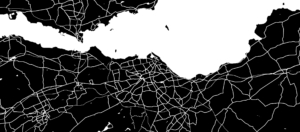
Disused railway stations in Edinburgh
- Abbeyhill railway station
- 55.957092, -3.167514
- One station platform still exists but is covered by overgrown weeds and shrubs.
- A platform remains here and some tracks may be buried under spoil.
- https://en.wikipedia.org/wiki/Abbeyhill_railway_station
- https://www.railscot.co.uk/locations/A/Abbeyhill/
- Balerno railway station
- Balerno High School, 5 Bridge Rd, Balerno, Edinburgh EH14 7AQ
- The site is now occupied by a school.
- https://en.wikipedia.org/wiki/Balerno_railway_station
- Balgreen Halt railway station
- 55.9383, -3.252
- Blue sign
- The stationmaster’s house remains standing, in the site which has been landscaped as part of a garden.
- https://en.wikipedia.org/wiki/Balgreen_Halt_railway_station
- Barnton railway station
- 55.9611, -3.307
- The site is now housing. The station frontage onto Whitehouse Road is now a row of shops. Further east the trackbed is a walkway.
- https://www.railscot.co.uk/locations/B/Barnton/
- Blackford Hill railway station
- 55.927232, -3.188258
- Little remains of the station.
- https://www.railscot.co.uk/locations/B/Blackford_Hill/
- Bonnington railway station
- 55.9725, -3.188
- Brown bridge with red posts, short tunnel
- The trackbed is now a footpath. The platforms and station building remain.
- https://www.railscot.co.uk/locations/B/Bonnington/
- Colinton railway station
- 55.907644, -3.260443
- The station is now part of the Water of Leith cyclepath that follows much of the route of the Balerno Loop and the goods yard is a car park.
- The station building survived closure to passengers and was only demolished immediately before the line’s closure. The line remained open until 1967 for goods. The goods platform still remains, the passenger platform is a low overgrown mound. Since
- https://en.wikipedia.org/wiki/Colinton_railway_station
- https://www.railscot.co.uk/locations/C/Colinton/
- Corstorphine railway station
- 55.941309, -3.278732
- The site has since been built over by Mactaggart & Mickel, and is now occupied by the Paddockholm Estate. Station Road nearby is named for the former station.
- The station closed in 1968. Since closure the site has been entirely built over with housing, accessed by ‘The Paddockholm’ which runs through the northern part of the site.
- https://en.wikipedia.org/wiki/Corstorphine_railway_station
- https://www.railscot.co.uk/locations/C/Corstorphine_2nd/
- Craigleith railway station
- 55.956439, -3.244493
- The trackbed is now a footpath. The platforms remain and Queensferry Road still crosses the former line with a bridge.
- https://www.railscot.co.uk/locations/C/Craigleith/
- Craiglockhart railway station
- 55.927914, -3.228276
- With stairs
- The platform still exists with building recesses
- https://en.wikipedia.org/wiki/Craiglockhart_railway_station
- https://www.railscot.co.uk/locations/C/Craiglockhart/
- Currie railway station
- 55.902905, -3.284282
- The station is now part of the Water of Leith Walkway that follows much of the route of the Balerno Loop. The platforms survive only as low earthen mounds and the old goods shed was used by the council for storage.
- https://en.wikipedia.org/wiki/Currie_railway_station
- Currie [1st] (1848-1874) Curriehill (1874-1951) Curriehill (1987-)
- Curriehill, Currie EH14 5TW
- The present day station dates from 1987. The new platforms are not staggered and the car park is the site of the former goods yard.
- https://www.railscot.co.uk/locations/C/Curriehill/
- Dalry Road railway station
- 55.9409, -3.221
- A green bridge
- The line is now closed. The section between Haymarket West Junction and Dalry Road station is now a roadway. A short portion of the platform at Dalry Road still exists.
- https://www.railscot.co.uk/companies/W/Wester_Dalry_Branch_and_Dalry_Road_Lines_Caledonian_Railway/
- Davidson’s Mains railway station
- 55.9662, -3.277
- The station site is now housing.
- https://www.railscot.co.uk/locations/D/Davidson’s_Mains/
- Duddingston & Craigmillar railway station
- 55.935301, -3.142234
- The eastbound remains and westbound has gone. No buildings survive. The good yard side now is a traveling community.
- https://www.railscot.co.uk/locations/D/Duddingston/
- East Pilton railway station (Pilton Junction East)
- 55.970908, -3.229105
- The truck bed now is a footpath
- https://www.railscot.co.uk/locations/P/Pilton_Junction_East/
- https://www.railscot.co.uk/locations/E/East_Pilton_Halt/
- Easter Road Park Halt railway station
- 55.962386, -3.162239
- After closure the cutting to the south, with the halt, was infilled. The cutting northwards became part footpath and part sports ground. The cutting to the south and site of the halt is now built over.
- https://www.railscot.co.uk/locations/E/Easter_Road_Park_Halt/
- Easter Road railway station
- 55.961325, -3.170744
- The line is now out of use. Both platforms survive although the northern of the two has been cut back to only the east of the road bridge.
- https://www.railscot.co.uk/locations/E/Easter_Road/
- Gilmerton railway station
- 55.8999, -3.1274
- The platform and station building were demolished in 1976 and the two sidings were lifted in 1978.
- The trackbed remains intact but very overgrown. The railway cottage is still in use as a house. Little remains of the station itself. The nearby colliery sites on either side of the line are in light industrial use.
- https://en.wikipedia.org/wiki/Gilmerton_railway_station
- https://www.railscot.co.uk/locations/G/Gilmerton/
- Gogar railway station, NBR
- 55.926, -3.3233
- A loading bank remains at the closed goods station. Nothing remains of the passenger station.
- https://www.railscot.co.uk/locations/G/Gogar/
- Gorgie East railway station
- 55.933298, -3.236635
- https://www.railscot.co.uk/locations/G/Gorgie_East/
- Granton railway station
- 55.9861, -3.2216,
- Royal Forth Yacht Club, Granton Harbor, Middle Pier, Edinburgh EH5 1HF
- Some railway lines remain in place on the pier. Nothing remains of the passenger station. The slip still exists. The site of the station is now the Royal Forth Yacht Club
- https://www.railscot.co.uk/locations/G/Granton/
- Granton Road railway station
- 55.9722, -3.2143
- The platforms survived and the trackbed became a footpath.
- https://www.railscot.co.uk/locations/G/Granton_Road/
- Hailes Halt railway station
- 55.913, -3.262
- The halt would have had little substantial infrastructure and is now part of a cyclepath that follows much of the route of the Balerno Loop.
- Trackbed and platform remains at the site of Hailes Halt
- https://en.wikipedia.org/wiki/Hailes_Halt_railway_station
- House o’Hill Halt railway station
- 55.964203, -3.259725
- A short bridge
- https://www.railscot.co.uk/locations/H/House_o%5E_Hill_Halt/
- Jock’s Lodge railway station
- 55.956540, -3.146788
- This short lived station opened in September 1847 by the North British Railway. It was only open for 10 months, closing on 1 July 1848.
- https://en.wikipedia.org/wiki/Jock%27s_Lodge_railway_station
- Joppa railway station
- 55.9472, -3.1016
- The station building remains, however the platforms have been removed.
- The building L shaped in plan, still remains.
- https://en.wikipedia.org/wiki/Joppa_railway_station
- https://www.railscot.co.uk/locations/J/Joppa_2nd/
- Joppa railway station, E&DR
- 55.944972, -3.102487
- The station was opened on 16 July 1847 by the North British Railway, although it didn’t appear in any publications until Topham’s Patented Railway Timetables in May 1848. It closed on 16 May 1859,[1] being replaced by Joppa.
- Junction Road railway station, Edinburgh
- 55.9748, -3.1795
- Renamed in 1923 as Junction Bridge under the ownership of the London, Midland and Scottish Railway before closing permanently on 16 June 1947. The signal box closed in 1952.
- https://en.wikipedia.org/wiki/Junction_Road_railway_station,_Edinburgh
- Juniper Green railway station
- 55.902905, -3.284282
- Same location as Currie railway station
- The station is now part of the Water of Leith cycle path that follows much of the route of the Balerno Loop and nothing remains of the station.
- Leith Central railway station
- 55.969616, -3.171170
- Wonder World Soft Play (near)
- The site of the station currently houses a children’s soft-play centre, formerly Leith Waterworld, and a supermarket. The buildings which housed the station offices, waiting room etc. the station clock and the shops at street level all still stand at the foot of Leith Walk. A tenement block on the opposite side of Easter Road which was demolished as part of the construction of the station has now been replaced by modern housing.
- https://en.wikipedia.org/wiki/Leith_Central_railway_station
- Leith Citadel railway station
- The Citadel Youth Centre, 175 Commercial Street, Edinburgh, EH6 6JE
- Leith Citadel station is a Category B listed building and is one of the remaining structures from the original line. It is now used as the Citadel Youth Centre.
- https://en.wikipedia.org/wiki/Leith_Citadel_railway_station
- Leith North railway station
- 55.9784, -3.1807
- The site is now occupied with flats and nearby warehouses.
- https://en.wikipedia.org/wiki/Leith_North_railway_station
- Leith Walk railway station
- 55.9621, -3.1802
- Parts of the station platforms still exist although they are overgrown with weeds. The station buildings on Leith Walk were demolished in the 1970s. The railway line through the station was used to carry waste from Powderhall Waste Transfer Station to a landfill site in East Lothian until 2016, when the plant closed.
- https://en.wikipedia.org/wiki/Leith_Walk_railway_station
- Meadowbank Stadium railway station
- 55.957717, -3.156626
- The platform remains overgrown. The westbound line was lifted when the route west to Abbeyhill Junction was closed and lifted.
- https://www.railscot.co.uk/locations/M/Meadowbank_Stadium/
- Merchiston railway station
- 55.934636, -3.228749
- The part of the track occupying the former station at Merchiston is now a footpath, extending to a service road leading west to Slateford Yards.
- https://en.wikipedia.org/wiki/Merchiston_railway_station
- Morningside Road railway station
- 55.925496, -3.209509
- The station was located by Morningside Road, where the road bridge crosses the suburban line, and was accessed via a gate on the west side of the road, opposite the Morningside Clock.
- Today the station building has been converted for commercial use. The outer circle platform was removed to allow Mark 3 coaching stock to operate on the line. Abellio ScotRail has an advertising hoarding on the bridge next to the clock, where it displays posters advertising passenger rail services. The iron footbridge from the former station still stands to this day, connecting Maxwell Street to Balcarres Street
- https://en.wikipedia.org/wiki/Morningside_Road_railway_station
- Murrayfield railway station
- 55.9455, -3.232
- The station opened on 1 August 1879 by the Caledonian Railway. There was a large goods yard as well as Coltbridge Stone Depot. Two signal boxes were built, one to the north of the southbound platform and the other to the southwest. These were later removed and replaced by a single box to the northwest, next to the goods yard. It was downgraded to a ground frame in 1944. The station closed on 30 April 1962.
- The platforms still survive but the station buildings are gone.
- https://en.wikipedia.org/wiki/Murrayfield_railway_station
- Newhaven railway station (Edinburgh)
- 55.9764, -3.1967
- The station was opened on 1 August 1879 by the Caledonian Railway. The station building and its offices were on Craighall Road. There were two goods yards: Newhaven Goods and Minerals and Leith High Depot. Two additional platforms were built in 1902 to serve the Leith New Lines. The station closed on 30 April 1962.
- The new lines closed in 1966 and the goods yards closed in 1968. The platforms and station building offices remain.
- https://en.wikipedia.org/wiki/Newhaven_railway_station_(Edinburgh)
- Newington railway station (Edinburgh)
- 55.930695, -3.172858
- Newington station closed in 1962, when passenger rail services were withdrawn from the Edinburgh Suburban line although the line itself was retained for rail freight use. The route continues to be used for freight services to this day, so freight trains avoid Edinburgh’s main stations of Edinburgh Waverley and Haymarket, and occasionally diverted passenger trains also pass along this line.
- https://en.wikipedia.org/wiki/Newington_railway_station_(Edinburgh)
- Niddrie railway station
- 55.9347, -3.0948
- The station stayed open for goods traffic until 1950.
- https://en.wikipedia.org/wiki/Niddrie_railway_station
- Piershill railway station
- 55.9569, -3.1514
- The route was used for infrequent movement of waste from Powderhall to the East Coast Main Line until 2016.
- Piershill was near the temporary Meadowbank Stadium station which was opened during the Commonwealth Games in Edinburgh in 1986; Meadowbank station closed shortly after the games finished.
- https://en.wikipedia.org/wiki/Piershill_railway_station
- Pinkhill railway station
- 55.9417, -3.2643
- The disused track bed is now a cycle and footpath, forming part of the City of Edinburgh’s Quiet Route 9. The platforms and ticket office of the former station remain in place.
- https://en.wikipedia.org/wiki/Pinkhill_railway_station
- Port Edgar railway station
- 55.993585, -3.416318
- The site later became a naval base and the signal box closed in 1929. Some parts of the line embedded in concrete remain.
- https://en.wikipedia.org/wiki/Port_Edgar_railway_station
- Portobello railway station (E&DR)
- 55.949, -3.118
- It remained in use until 1846 when a replacement station was opened nearby on the NBR Main Line.
- https://en.wikipedia.org/wiki/Portobello_railway_station_(E%26DR)
- Portobello railway station (NBR)
- 55.949454, -3.117677
- The little house in Station Brae. Hidden behind trees, in a small yard, off a busy road is the old Portobello station house. Photograph taken in April 2007, almost 43 years after the station closed. The former island platform was reached via a subway
- https://www.railscot.co.uk/locations/P/Portobello_3rd/
- Powderhall railway station
- 55.967274, -3.188346
- It had a ticket office and waiting rooms on both platforms but it had no goods yard. It closed on 1 January 1917. The platforms and trackbed still survive but the station buildings have been demolished.
- https://en.wikipedia.org/wiki/Powderhall_railway_station
- Edinburgh Princes Street railway station
- The Waldorf Astoria Edinburgh – The Caledonian
- The hotel still operates on the site and has been renamed the Waldorf Astoria Edinburgh – The Caledonian. Part of the station space still remains within it and the vehicle entrance screen is still visible at the side of the hotel. The former Parcels Office survived on Lothian Road between the hotel and the West Approach Road, until a major office development was constructed on its site in the 1990s.
- https://en.wikipedia.org/wiki/Edinburgh_Princes_Street_railway_station
- Ravelrig Junction Platform railway station
- 55.893872, -3.371935
- The presence of a single platform indicates that the station was mainly or only served by trains on the Balerno line as a likely requested stop, only during daylight hours as suggested by a lack of lighting. The junction stood nearby with no crossover points.
- https://en.wikipedia.org/wiki/Ravelrig_Junction_Platform_railway_station
- St Leonards railway station (Scotland)
- Holyrood Distillery, 19 St Leonard’s Ln, Edinburgh EH8 9SH
- Both the coal depot and the railway line are now gone and have been redeveloped into housing. The goods shed is the only surviving building and is a category B listed building. It is currently planned to be converted into a whisky distillery & visitor center by 2019. The route of the line can still be followed, protected from development by the construction of a cycle path where the tracks run.
- https://en.wikipedia.org/wiki/St_Leonards_railway_station_(Scotland)
- Saughton railway station
- 55.9329, -3.2744
- Scotland Street railway station
- King George V Park, 94 Eyre Pl, Edinburgh EH3 5EN
- The site of the station is now part of a public park.
- https://en.wikipedia.org/wiki/Scotland_Street_railway_station
- South Leith railway station
- 55.9765, -3.1654
- South Queensferry railway station
- First: 55.988841, -3.396381
- Second: 55.990070, -3.401964
- The first station closed and was relocated when the line was extended to Port Edgar on 2 September 1878. It became a goods yard.
- This station replaced the former terminus on 2 September 1878. It closed on 5 March 1890 but reopened on 1 December 1919 as South Queensferry Halt. To the east was a siding. It closed permanently on 14 January 1929.
- https://www.railscot.co.uk/locations/S/South_Queensferry_Halt/
- Trinity railway station
- 55.9791, -3.2048
- The line is now a footpath. The platforms and station building remain.
- https://en.wikipedia.org/wiki/Trinity_railway_station
- https://www.railscot.co.uk/locations/T/Trinity_2nd/
- Turnhouse railway station
- 55.951372, -3.342127
- The station closed on 22 September 1930.
- Nothing remains of the passenger station and the goods station is now in other uses.
- Edinburgh Airport opened in 1947 but the station didn’t reopen to serve it.
- https://www.railscot.co.uk/locations/T/Turnhouse/


Recent comments