
Can machine learning and satellite data help detect land use?
 Torben Sell, a lecturer in Machine Learning at the School of Mathematics, talks about his experiences of attending an AIMday and the resulting project with the Pentland Land Managers Association.
Academic researchers in the School of Mathematics regularly participate in various knowledge exchange activities with external partners and across Schools. One format that has proved immensely fruitful in the past are Academic Industry Meeting days (AIMdays®). These are inspiring events which connect university researchers with industry stakeholders to discuss contemporary challenges faced in practice.
When I joined the School of Mathematics, I attended the Digital Frontiers AIMday coordinated by Edinburgh Innovations. Alongside attending other sessions, including e.g. discussing questions surrounding how to control large numbers of model parameters in consumer AI, I was particularly interested in a problem posed by the Pentlands Land Managers Association (PLMA).
The challenge presented by the PLMA was how to reduce the cost of natural capital baselining. That is, how can we cost-effectively estimate the current levels of biodiversity, stored carbon, or amount of groundwater in a particular land area. Currently, the excessive costs associated with obtaining a trustworthy baseline prevent small landowners from accessing large scale investments aimed at biodiversity or carbon projects. This is a particular challenge faced by farmers in the Pentlands Regional Park, a popular natural habitat enjoyed by many people living in Edinburgh and its surroundings.
Jointly with the PLMA and researchers at the School of GeoSciences, I have been investigating how clustering algorithms can be used to detect various land use types from satellite data alone, omitting the requirement for expensive ground surveys.
After the satellite data had been pre-processed by Dave McKay from EPCC, the University’s and UK’s leading centre for supercomputing, I worked with Lucy Wells, a PhD student in the School of GeoSciences. Lucy is currently working on classifying land use in the tropics, making this project an interesting one much closer to home.
The initial findings from this project phase have been promising – some types of land use (e.g. trees and water) were consistently identified over the period of interest (2018 – 2023). Further work will be required to refine the estimates and assess the associated uncertainty around the predictions, as well as linking these with the natural capital baseline of interest.
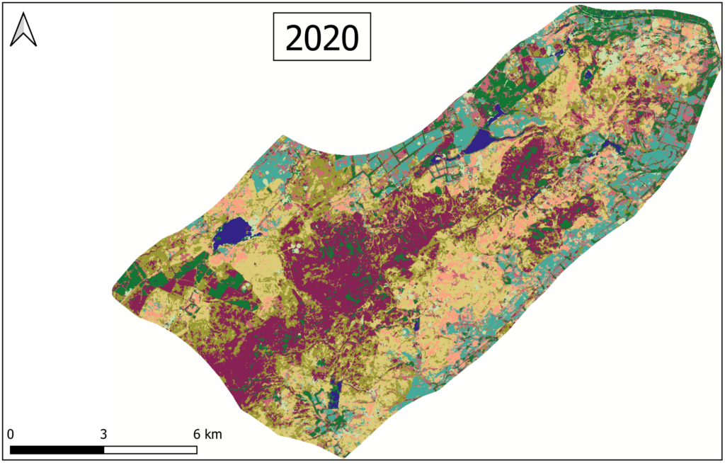
Pentlands land classification (2020)
In an additional step of the project starting in May, Saraswati Thapa, Simon Moulds, and Simon Mudd (all researchers in GeoSciences) will investigate the impact of recent changes in land use on the flood management in the Pentlands Regional Park area.
I thoroughly enjoyed working on this collaborative project with inspiring people. It offered additional development opportunities, including PhD supervision which I found particularly rewarding. After such a positive experience of working with the PLMA, I am looking forward to continuing creating real world impact by working with further industry partners, both on interdisciplinary projects, as well as projects closely aligned with my core research area of developing new statistical learning methodology.