This is my second circle of the Moss today. When I walked with Clyde this morning, I noticed that the contractors were back on site. The fence across the central path had been reinstalled – this time with a lower, sturdier structure. This version would be easy to climb over, for anyone who was determined. I think it will have more chance of staying put, but I will be interested to see what happens after the last attempt was destroyed in the night.
I meet Bob outside the station. He lives on the other side of the track and for decades, he has walked and jogged round the Moss. Bob is a retired maths professor and moved up to Glasgow in 1980. He discovered a love of hill walking and has been an active member of the Ramblers ever since. Like David K, Bob learnt about my project from Carol. I am grateful to her for recruiting new walkers on my behalf! Bob has a slight ankle injury today, so he tells me he might struggle a bit, but should be fine to complete a circle. Bob no longer runs here, but he often walks this route. He tells me he is ‘law abiding’ and always sticks to the main paths.
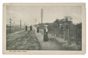
My semi-regular run takes me round the Moss in the other direction before cutting through Boghead Wood and up Christine’s Way to the canal. This is one of Bob’s favourite routes, too. He tells me about the other routes and pathways that he often travels. One of these is the Ladies’ Mile (or Lady’s Mile, as it is sometimes spelled), which I have never walked along, but which is clearly visible on the other side of the trainline. There is a postcard at the Auld Kirk Museum in Kirkintilloch, with information about the path on the arts and heritage website, Trails + Tails (the project that commissioned the Stacks artworks by Dug MacLeod, Simon Whatley and Toby Paterson, which I explored with Ada, and which Iona climbed onto):
This postcard relates to an access controversy of 1904. The Lady’s Mile footpath ran between Boghead and Lenzie Station. Most of its route was on railway property along the south side of the line. The path was not an official right of way and to retain ownership the railway company locked the gates at either end from time to time, to the annoyance of local residents who vented their frustration by vandalising the chain that held the gate shut. However, a few months later, path users were forced to acknowledge the railway’s right and recognise that the closure had been intended to last about 24 hours. This postcard is postmarked 12th December 1905 and is addressed to South India with Christmas and New Year good wishes.
This anecdotal evidence of vandalism at the start of the twentieth century suggests that disputes about land use and access are nothing new here. I wonder whether I have met some of the decedents of those frustrated residents.
Bob and I catch glimpses of the sunlit Campsies through the trees, and he tells me that he was up there earlier today, playing indoor bowls in village of Fintry, which is hidden up in the hills in the strath of the River Endrick. I have visited Fintry from time to time and was there earlier this month with my children, shopping for Mother’s Day presents at the Courtyard Cafe – a favourite of Bob’s wife and her friends. Bob has been bowling for years now at the Sports and Recreation Club there (he tells me that there is another good cafe there) and he recently persuaded some of his Rambling friends to give it a go.
As we wander down the boardwalk, we look out towards Bishopbriggs, and Bob points out the route over the humpback bridge that links the Ladies’ Mile to Boghead Wood. I will walk this with Clyde one day soon. Bob also tells me about the route from the bottom of Victoria Road, past the Gadloch and over to Auchinloch (which has a pub that I have always wanted to try out). I am grateful to Bob for all these tips for further exploration of the Lenzie area. I remember that all this used to be connected to the Moss, prior to the railway line and the mid nineteenth century building works that created both Bob and my houses.
At the exact spot where Eilidh and I met Janice last week, we find a laminated sign pinned to a fencepost. The notice is about restoration works and tells us that ‘further access and biodiversity works will be undertaken in line with conservation objectives set out in East Dunbartonshire Council’s Lenzie Moss [Local Nature Reserve] Management Plan’. There is a list of works undertaken so far:
◦ Rewetting, regrading and reprofiling works to initiate recovery of peat and vegetation
◦ Scrub removal and thinning of Birch woodland
◦ Habitat Creation – ponds, dead hedges etc
◦ Path/boardwalk upgrades and maintenance
The sign includes QR code links to information about the NatureScot Peatland ACTION programme and the Scottish Outdoor Access Code. It also explains why it is important to protect peat bogs:
◦ Stores carbon reducing greenhouse gas release
◦ International important habitat (European Priority)
◦ Regulates water flow, quality and stores water
◦ Healthy peat supports key wetland species
There are pictures, of a skylark, a meadow pipit, a common snipe, a roe deer and a sundew. There are also some suggestions ‘for your own safety and protection of this site’:
◦ Stay on designated pathways and boardwalk
◦ Do not wander beyond fencing, dead hedges or into the peat bog
◦ Keep your dog(s) alongside you or on a short lead at all times
◦ Admire but do not disturb the wildlife
The sign seems to respond directly to the concerns raised by Andy and Janice: ‘Lenzie Moss is a very sensitive site, walking across the peatland can cause irreversible [sic], undoing thousands of years of growth and emitting greenhouse gases such as CO2 or methene!’ It concludes with a simple plea: ‘Please Respect Lenzie Moss’.
It is good to see this effort to communicate the reasons and intentions of the conservation work. But I have seen over the last year that these A4 signs tend to get damaged or removed easily. I wonder whether more permanent and enduring signs might be of value.
In return for Bob’s walking tips, I invite him to explore a path that is new to him, and we set off across the bog and through the woodland to the old peat shed. We stick to what I assume is one of the designated pathways, but I allow myself a short detour to inspect the new fence. Bob asks me about the ruins, and I show him the concrete platform, which I am assuming was part of the railway infrastructure. This afternoon, Bob and I have shared what we know about this place. I now have some new walking routes to explore, and Bob has seen a side of the Moss that he hadn’t yet encountered after all those years of running and walking here.