Summary
The numerical modelling code I’m using is OpenGeoSys which is an open source method coupling thermo-hydro-mechanical-chemical (THMC) processes. At this stage I’ve created a hydro-mechanical (HM) model and will be developing this further to include thermal processes in the future.
Hydro-mechanical model
The initial hydro-mechanical model has been developed to try to replicate the surface uplift associated with rising mine water. When the pumps that removed water to facilitate mining were switched off following colliery closure mine water was allowed to rebound to natural levels. This rebound has been linked to surface uplift in several coal mining areas (1) but never modelled using a hydro-mechanical model before.
A simple 2D fully saturated model has been developed comprising one level of pillar-and-stall (stoop-and-room) workings. The deformation boundary conditions are shown below with the bottom boundary completely static and other boundaries allowed to move vertically but not horizontally. Fluid pressure boundary conditions were set a the top and bottom of the model to represent hydrostatic pressure. A lithostatic pressure is added via a source term at the top of the model to represent the un-modelled overburden from surface to model top.
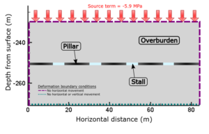
Schematic showing HM model setup
A water level rise of 40m was modelled through two equal 20m pressure increases. The resultant modelled vertical displacement is shown below for a 20m rise (left) and a 40m rise (right). This indicates that the vertical displacement rises linearly with water level. The modelled uplift is in the same order of magnitude as that recorded in Midlothian. The model shows 1.4mm of surface uplift for each m of water level rise compared to 1mm/m recorded in Midlothian (2).
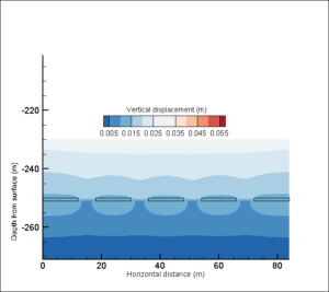
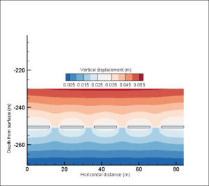
Cross section showing modelled vertical displacement for a water level rise of 20m (left) and 40m (right)
Further information
(1) Selected papers for further details on mine water related surface uplift:
Bateson, L., Cigna, F., Boon, D. & Sowter, A. 2015. The application of the intermittent SBAS (ISBAS) InSAR method to the South Wales Coalfield, UK. International Journal of Applied Earth Observation and Geoinformation, 34, 249–257, https://doi.org/10.1016/j.jag.2014.08.018.
Gee, D., Bateson, L., et al. 2017. Ground Motion in Areas of Abandoned Mining: Application of the Intermittent SBAS (ISBAS) to the Northumberland and Durham Coalfield, UK. Geosciences, 7, 85, https://doi.org/10.3390/geosciences7030085.
Bekendam, R.F. & Pottgens, J.J. 1995. Ground movements over the coal mines of southern Limburg , The Netherlands , and their relation to rising mine waters. In: Proceedings of the Fifth International Symposium on Land Subsidence, IAHS Publication No 234.
(2) Satellite (InSAR) data showing surface uplift related to mine water level rise in Midlothian can be found here