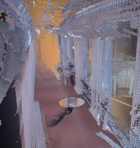
It was now time to test and understand LiDAR in its full capacity. For the group’s first interactions with LiDAR we decided to experiment with Leica BLK360 on a larger scale, the ECA Sculpture Court.
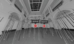
Described as “the neo-classical heart of the Main Building”, ECA Sculpture Court is a large room commonly used for exhibitions and other events. It presents a second floor with a balcony-gallery layout, which provides the opportunity to experiment scan-alignment at different heights. And, whenever not used for exhibitions, it presents a large clear out area, with lot of surface for experimentation, the ideal set-up to get to know LiDAR technology better.
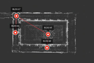
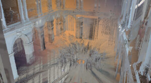
 Across this experimentation four scans were performed, each by a different member of the group. The first, positioned in the center of the room, the
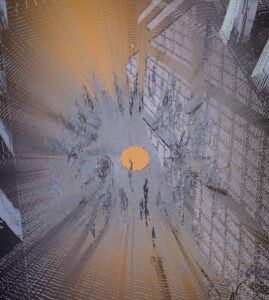
group suggested to get creative. During the entire scan of 6 minutes 50 seconds , we, about 8 people, moved together in circles around the scanner,
sometimes inverting direction. The intention behind was to understand how the scan copes with the presence of human movement. Once the scan
revealed itself, the results were receiver as a wonderful surprise to all. It
showed an undefined circular pattern around its blind-spot, something that look somewhat ritual of the spirit world, around a void . Thus, it was an important practice to understand how this technology, commonly used for technical purposes, could also be used as some sort of a creative tool.
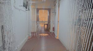
The following to scans were performed in the gallery areas, with the intent of both further understand the scan alignment procedures, and compare how the scan performs under more inclosed spaces. As expected we concluded that, more enclosed spaces lead to more concentrated point clouds, and therefore a more detailed representation of the surfaces. We got also to understand, that the “automatic prei-alignement” feature (Cyclone 360 app) can only be effective within lines of sight between two different scan positions.
Lastly, we moved to the second floor balcony, with direct sight over the first central scanned position. This scan was performed with the intent of understanding if the scan alignment could be performed at various height levels. Although we managed to make it happen through manual alignment, it seemed that this specific device is not designed for such without the help of external software.
Summing up. After testing the LiDAR scanner, at a larger scale, we can now understand how effective it can be for capturing large infrastructures, and the right techniques to do so. We also found that this technical device can be used as a creative tool, through more unconventional and experimental practices, that could enrich the project greatly. We also understood, how the device has its own limitations, and how this come be overcome through the use of external software.
More interesting findings and explorations will soon come, and so we’ll keep you posted.